IMAGES TAKEN NEAR TO
Wilmer Road, BRADFORD, BD9 4RX
Introduction
This page details the photographs taken nearby to Wilmer Road, BD9 4RX by members of the Geograph project.
The Geograph project started in 2005 with the aim of publishing, organising and preserving representative images for every square kilometre of Great Britain, Ireland and the Isle of Man.

There are currently over 7.5m images from over14,400 individuals and you can help contribute to the project by visiting https://www.geograph.org.uk
Image Map (Loading...)


Getting Data...Please wait
Leaflet Map data © OpenStreetMap
Images are licensed for reuse under creativecommons.org/licenses/by-sa/2.0
Notes
- Clicking on the map will re-center to the selected point.
- The higher the marker number, the further away the image location is from the centre of the postcode.
Image Listing (210 Images Found)
Images are licensed for reuse under creativecommons.org/licenses/by-sa/2.0
Image
Details
Distance
1
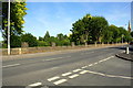
Junction of Wilmer Road and Milford Place
There is an Ordnance Survey benchmark Image on the wall opposite the junction, about 4 feet right of the wall pier which is right of the lamppost and hydrant marker post.
Image: © Roger Templeman
Taken: 17 Jul 2017
0.01 miles
2
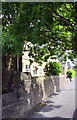
Stone wall outside Sunday School, Wilmer Road
There is an OS benchmark Image on the high section of wall at its junction with the main wall section.
Image: © Roger Templeman
Taken: 10 Aug 2017
0.01 miles
3
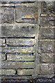
Benchmark on Wilmer Road wall
Ordnance Survey cut mark benchmark described on the Bench Mark Database at http://www.bench-marks.org.uk/bm87446
Image: © Roger Templeman
Taken: 10 Aug 2017
0.02 miles
5
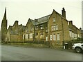
Former St John's Sunday School, Birr Road side
The main reason for photographing this part of Bradford on this grey December day was a news story on a local website that this former Methodist Sunday school, which has certainly seen better days, was to be demolished to make way for housing. The article claimed it to be grade II listed but close inspection of Historic England's map shows that only the church itself (still in use by Catholics) is listed.
Image: © Stephen Craven
Taken: 11 Dec 2021
0.02 miles
6
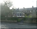
Former St John's Sunday School, Wilmer Road side
The main reason for photographing this part of Bradford on this grey December day was a news story on a local website that this former Methodist Sunday school, which has certainly seen better days, was to be demolished to make way for housing. The article claimed it to be grade II listed but close inspection of Historic England's map shows that only the church itself (still in use by Catholics) is listed.
Image: © Stephen Craven
Taken: 11 Dec 2021
0.02 miles
7
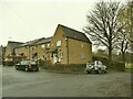
St Cuthbert's Unity Centre - Wilmer Road
Image: © Betty Longbottom
Taken: 18 Oct 2011
0.03 miles
9
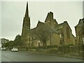
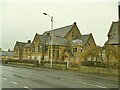
Ukrainian Catholic church, Manningham - east end
The church was formerly St John's Methodist, opened in 1879 and noted in the Grade II listing (list entry 1132919) as "one of the first [Methodist churches] built in Bradford to rival the Church of England Gothic." Now dedicated to the Holy Trinity and Our Lady of Pochaiv (a town that Wikipedia says contains the second largest Eastern Orthodox monastery in Ukraine). There is an English-speaking Catholic church nearby, but presumably there were reasons the Ukrainians didn't want to join them.
This is liturgically the east end, though geographically north-west.
Image: © Stephen Craven
Taken: 11 Dec 2021
0.03 miles
10
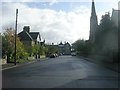
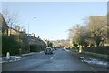
Birr Road - looking toward Park View Road
Image: © Betty Longbottom
Taken: 18 Oct 2011
0.04 miles