IMAGES TAKEN NEAR TO
Heaton Road, BRADFORD, BD9 4PS
Introduction
This page details the photographs taken nearby to Heaton Road, BD9 4PS by members of the Geograph project.
The Geograph project started in 2005 with the aim of publishing, organising and preserving representative images for every square kilometre of Great Britain, Ireland and the Isle of Man.

There are currently over 7.5m images from over14,400 individuals and you can help contribute to the project by visiting https://www.geograph.org.uk
Image Map (Loading...)


Getting Data...Please wait
Leaflet Map data © OpenStreetMap
Images are licensed for reuse under creativecommons.org/licenses/by-sa/2.0
Notes
- Clicking on the map will re-center to the selected point.
- The higher the marker number, the further away the image location is from the centre of the postcode.
Image Listing (272 Images Found)
Images are licensed for reuse under creativecommons.org/licenses/by-sa/2.0
Image
Details
Distance
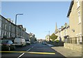
2
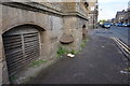
Bradford Woodworkers
On Heaton Road, Manningham.
Image: © Ian S
Taken: 20 May 2016
0.01 miles
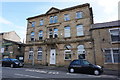
3
NE corner of Lister Mills and houses on Heaton Road
There is an Ordnance Survey benchmark Image on the near corner, left hand face, of the Mill jut
Image: © Roger Templeman
Taken: 17 Jul 2017
0.02 miles
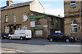
4

Beamsley Road viewed from Heaton Road
A cobbled road in the heart of the Lister's Mill complex. Not a nice place to be after dark I would imagine.
Image: © Stephen Armstrong
Taken: 1 Apr 2018
0.02 miles
5
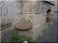
Anti Urinating Shield
To stop people from urinating in the corner of the building. At Manningham Mill on Heaton Road, Manningham. http://www.geograph.org.uk/photo/4961753
Image: © Ian S
Taken: 20 May 2016
0.02 miles
6
Anti Urinating Shield
To stop people from urinating in the corner of the building. At Manningham Mill on Heaton Road, Manningham. http://www.geograph.org.uk/photo/4961740
Image: © Ian S
Taken: 20 May 2016
0.02 miles
7

OS Cut Benchmark, Beamsley Road
This is near the NE corner of the former Lister's silk mill at the bottom of Beamsley Road. Details at https://www.bench-marks.org.uk/bm86593
Image: © Stephen Armstrong
Taken: 1 Apr 2018
0.02 miles
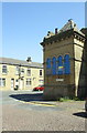
8

Lister's Mills former Silk Mill, Heaton Road/Beamsley Road
Part of the huge 27 acre Lister's Mills complex. Now, sadly, it is just a disused, roofless shell. There is an OS Cut Benchmark Image approximately 4 metres right of the corner on Beamsley Road.
Image: © Stephen Armstrong
Taken: 1 Apr 2018
0.02 miles
9
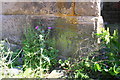
Benchmark on Beamsley Road face of Lister Mills
Ordnance Survey cut mark benchmark described on the Bench Mark Database at www.bench-marks.org.uk/bm86593
Image: © Roger Templeman
Taken: 17 Jul 2017
0.02 miles