IMAGES TAKEN NEAR TO
Wood Road, BRADFORD, BD9 4LW
Introduction
This page details the photographs taken nearby to Wood Road, BD9 4LW by members of the Geograph project.
The Geograph project started in 2005 with the aim of publishing, organising and preserving representative images for every square kilometre of Great Britain, Ireland and the Isle of Man.

There are currently over 7.5m images from over14,400 individuals and you can help contribute to the project by visiting https://www.geograph.org.uk
Image Map (Loading...)


Getting Data...Please wait
Leaflet Map data © OpenStreetMap
Images are licensed for reuse under creativecommons.org/licenses/by-sa/2.0
Notes
- Clicking on the map will re-center to the selected point.
- The higher the marker number, the further away the image location is from the centre of the postcode.
Image Listing (138 Images Found)
Images are licensed for reuse under creativecommons.org/licenses/by-sa/2.0
Image
Details
Distance
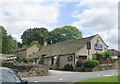
4
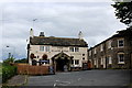
Black Swan, Frizinghall
Public House to be found just off Frizinghall Road
Image: © Chris Heaton
Taken: 1 Sep 2014
0.05 miles
5
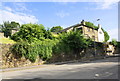
Frizinghall Road approaching The Black Swan pub
There is an Ordnance Survey benchmark Image on the wall between the two clumps of overhanging ivy
Image: © Roger Templeman
Taken: 13 Jul 2017
0.05 miles
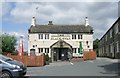

9
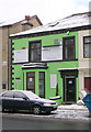
Simply Smooth Hair & Beauty - Keighley Road
Image: © Betty Longbottom
Taken: 9 Jan 2010
0.06 miles