IMAGES TAKEN NEAR TO
Aireville Road, BRADFORD, BD9 4HN
Introduction
This page details the photographs taken nearby to Aireville Road, BD9 4HN by members of the Geograph project.
The Geograph project started in 2005 with the aim of publishing, organising and preserving representative images for every square kilometre of Great Britain, Ireland and the Isle of Man.

There are currently over 7.5m images from over14,400 individuals and you can help contribute to the project by visiting https://www.geograph.org.uk
Image Map
Images are licensed for reuse under creativecommons.org/licenses/by-sa/2.0
Notes
- Clicking on the map will re-center to the selected point.
- The higher the marker number, the further away the image location is from the centre of the postcode.
Image Listing (161 Images Found)
Images are licensed for reuse under creativecommons.org/licenses/by-sa/2.0
Image
Details
Distance
1
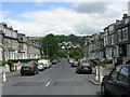
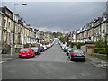
Aireville Road - viewed from Salisbury Street
Image: © Betty Longbottom
Taken: 21 Jun 2009
0.01 miles
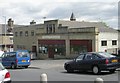
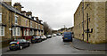
2
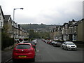
Bottom of Aireville Road, Frizinghall
With a view across the valley towards Owlet and Wrose.
Image: © Richard Vince
Taken: 15 May 2021
0.02 miles
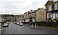
5
Aireville Road, Frizinghall
In its entirety, viewed from Midland Road towards Keighley Road.
Image: © Richard Vince
Taken: 15 May 2021
0.03 miles
6
Jamia Mosque Tabligh-ul-Islam - Aireville Road
Image: © Betty Longbottom
Taken: 21 Jun 2009
0.03 miles
7
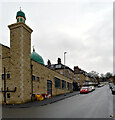
Jamiyat Tabligh-Ul-Islam mosque, Aireville Road, Frizinghall, Bradford
Image: © habiloid
Taken: 12 Dec 2020
0.04 miles
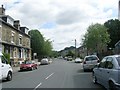
8
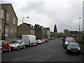
North end of Midland Road, Frizinghall
Image: © Richard Vince
Taken: 15 May 2021
0.05 miles
10
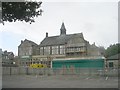
Frizinghall Primary School - viewed from Midland Road
Image: © Betty Longbottom
Taken: 15 Aug 2011
0.05 miles