IMAGES TAKEN NEAR TO
Ashwell Road, BRADFORD, BD9 4AU
Introduction
This page details the photographs taken nearby to Ashwell Road, BD9 4AU by members of the Geograph project.
The Geograph project started in 2005 with the aim of publishing, organising and preserving representative images for every square kilometre of Great Britain, Ireland and the Isle of Man.

There are currently over 7.5m images from over14,400 individuals and you can help contribute to the project by visiting https://www.geograph.org.uk
Image Map (Loading...)


Getting Data...Please wait
Leaflet Map data © OpenStreetMap
Images are licensed for reuse under creativecommons.org/licenses/by-sa/2.0
Notes
- Clicking on the map will re-center to the selected point.
- The higher the marker number, the further away the image location is from the centre of the postcode.
Image Listing (92 Images Found)
Images are licensed for reuse under creativecommons.org/licenses/by-sa/2.0
Image
Details
Distance
3
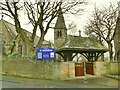
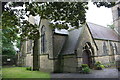
Lychgate of St Barnabas church, Heaton
See Image for the church itself.
Image: © Stephen Craven
Taken: 11 Dec 2021
0.03 miles
4
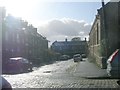
St Barnabas Church, Heaton
View from the top of Parsons Road
Image: © David Spencer
Taken: 3 Aug 2005
0.03 miles
5
St Barnabas Church
There is an Ordnance Survey benchmark Image on the left hand side of the church about 3 feet on the near side of the downpipe beside the buttress
Image: © Roger Templeman
Taken: 28 Jul 2017
0.04 miles
7
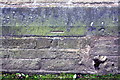
Benchmark on St Barnabas Church
Ordnance Survey cut mark benchmark described on the Bench Mark Database at www.bench-marks.org.uk/bm86952
Image: © Roger Templeman
Taken: 28 Jul 2017
0.04 miles
8
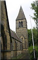
St Barnabas Church spire, an Ordnance Survey trig point
The spire is an Ordnance Survey intersection station trig point, see http://trigpointing.uk/trig/12977
Image: © Roger Templeman
Taken: 28 Jul 2017
0.04 miles
9
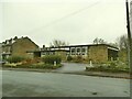
Heaton Village Hall
Opposite St Barnabas church, probably built in the 1960s or thereabouts as a church hall.
Image: © Stephen Craven
Taken: 11 Dec 2021
0.04 miles
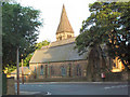
10
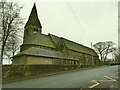
St Barnabas church, Heaton
An Anglican church, one of four in the recently combined parish of Girlington, Heaton and Manningham. Built in 1864 on land donated by the Earl of Rosse, for the Bradford Church Building Committee, the actual architect being apparently unknown. This was more than 50 years before the Bradford Diocese was formed; the Committee must have been a civic trust. Listed grade II (list entry 1314290).
Image: © Stephen Craven
Taken: 11 Dec 2021
0.04 miles