IMAGES TAKEN NEAR TO
Emm Lane, BRADFORD, BD9 4AP
Introduction
This page details the photographs taken nearby to Emm Lane, BD9 4AP by members of the Geograph project.
The Geograph project started in 2005 with the aim of publishing, organising and preserving representative images for every square kilometre of Great Britain, Ireland and the Isle of Man.

There are currently over 7.5m images from over14,400 individuals and you can help contribute to the project by visiting https://www.geograph.org.uk
Image Map
Images are licensed for reuse under creativecommons.org/licenses/by-sa/2.0
Notes
- Clicking on the map will re-center to the selected point.
- The higher the marker number, the further away the image location is from the centre of the postcode.
Image Listing (106 Images Found)
Images are licensed for reuse under creativecommons.org/licenses/by-sa/2.0
Image
Details
Distance
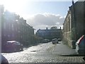
2
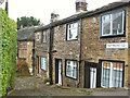
Hammond Square, Heaton
Many of the really old houses predating Bradford's nineteenth century expansion are built round courtyards set back from the street
Image: © David Spencer
Taken: 3 Aug 2005
0.02 miles
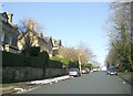
3
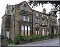
Elm Field Villas - Emm Lane
These are now empty and derelict.
Image: © Betty Longbottom
Taken: 4 Aug 2007
0.04 miles
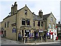
5
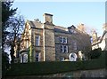
The Orchards Residential Home - Wilmer Drive
Image: © Betty Longbottom
Taken: 6 Dec 2008
0.05 miles
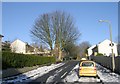
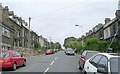
7
Junction of Heaton Road and Highgate
Image: © Roger Templeman
Taken: 10 Aug 2017
0.06 miles