IMAGES TAKEN NEAR TO
Cemetery Road, BRADFORD, BD8 9RZ
Introduction
This page details the photographs taken nearby to Cemetery Road, BD8 9RZ by members of the Geograph project.
The Geograph project started in 2005 with the aim of publishing, organising and preserving representative images for every square kilometre of Great Britain, Ireland and the Isle of Man.

There are currently over 7.5m images from over14,400 individuals and you can help contribute to the project by visiting https://www.geograph.org.uk
Image Map (Loading...)


Getting Data...Please wait
Leaflet Map data © OpenStreetMap
Images are licensed for reuse under creativecommons.org/licenses/by-sa/2.0
Notes
- Clicking on the map will re-center to the selected point.
- The higher the marker number, the further away the image location is from the centre of the postcode.
Image Listing (100 Images Found)
Images are licensed for reuse under creativecommons.org/licenses/by-sa/2.0
Image
Details
Distance
1
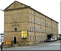
Cumberland House - Greenside Lane
Former mill now converted into offices.
Image: © Betty Longbottom
Taken: 10 Jul 2007
0.03 miles
4
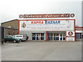
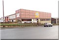
Maharaja Fabrics Ltd
On Cemetery Lane, Four Lane Ends, Bradford.
Image: © Ian S
Taken: 15 Oct 2016
0.04 miles
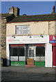
5
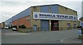
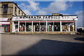
Maharaja Textiles Ltd - Cemetery Road
Image: © Betty Longbottom
Taken: 10 Jul 2007
0.04 miles
8
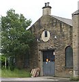
Back of Former Chapel on Wallis Street
Image: © Betty Longbottom
Taken: 10 Jul 2007
0.06 miles
9

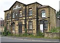
BPIS Ltd - Cemetery Road
Built in 1894, these were the former premises of the Bradford Provident & Industrial Society Ltd.
Image: © Betty Longbottom
Taken: 10 Jul 2007
0.07 miles
10
Substantial Sandwich Bar - Thornton Road
Image: © Betty Longbottom
Taken: 15 Nov 2009
0.11 miles