IMAGES TAKEN NEAR TO
Girlington Road, BRADFORD, BD8 9NN
Introduction
This page details the photographs taken nearby to Girlington Road, BD8 9NN by members of the Geograph project.
The Geograph project started in 2005 with the aim of publishing, organising and preserving representative images for every square kilometre of Great Britain, Ireland and the Isle of Man.

There are currently over 7.5m images from over14,400 individuals and you can help contribute to the project by visiting https://www.geograph.org.uk
Image Map (Loading...)


Getting Data...Please wait
Leaflet Map data © OpenStreetMap
Images are licensed for reuse under creativecommons.org/licenses/by-sa/2.0
Notes
- Clicking on the map will re-center to the selected point.
- The higher the marker number, the further away the image location is from the centre of the postcode.
Image Listing (193 Images Found)
Images are licensed for reuse under creativecommons.org/licenses/by-sa/2.0
Image
Details
Distance
1
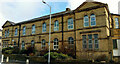
Girlington Community Centre, Girlington Road, Bradford
Housed in a former Wesleyan Sunday School, which was built in 1862 and rebuilt in 1881.
Image: © Stephen Armstrong
Taken: 4 Mar 2021
0.02 miles
2
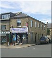
Girlington Mini-Market - Girlington Road
Image: © Betty Longbottom
Taken: 27 Sep 2011
0.02 miles
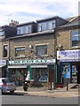
5

Shop Units on Willow Street, Girlington
Viewed from Kensington Street.
Image: © Stephen Armstrong
Taken: 1 Apr 2018
0.04 miles