IMAGES TAKEN NEAR TO
Toller Lane, BRADFORD, BD8 8QL
Introduction
This page details the photographs taken nearby to Toller Lane, BD8 8QL by members of the Geograph project.
The Geograph project started in 2005 with the aim of publishing, organising and preserving representative images for every square kilometre of Great Britain, Ireland and the Isle of Man.

There are currently over 7.5m images from over14,400 individuals and you can help contribute to the project by visiting https://www.geograph.org.uk
Image Map
Images are licensed for reuse under creativecommons.org/licenses/by-sa/2.0
Notes
- Clicking on the map will re-center to the selected point.
- The higher the marker number, the further away the image location is from the centre of the postcode.
Image Listing (175 Images Found)
Images are licensed for reuse under creativecommons.org/licenses/by-sa/2.0
Image
Details
Distance
1
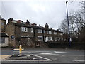
Grade II Listed Cottages, Toller Lane
Built 1820-1830 as 5 cottages, but it would seem the cottage at this end is one property, while the other 4 are also one property. These are through-by-light, meaning they have no back door, but they do have windows.
Image: © Stephen Armstrong
Taken: 1 Apr 2018
0.01 miles
3
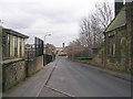
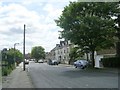
Junction of Church Street and Toller Lane (B6144), Bradford
Image: © habiloid
Taken: 23 Apr 2012
0.01 miles
4
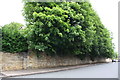
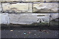
Stone wall in front of Ashwell House, Ashwell Road
There is an Ordnance Survey benchmark Image on the wall to the right of the wall pier where the wall height increases near the left hand side of the image
Image: © Roger Templeman
Taken: 20 Jul 2017
0.03 miles
5

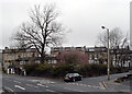
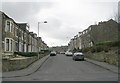
Slate Name Plaque, Abingdon Street
This is a first for me.
Image: © Stephen Armstrong
Taken: 1 Apr 2018
0.04 miles
8

OS Cut Benchmark, Church Street
This is on an electricity substation adjoining a former police station. Details at https://www.bench-marks.org.uk/bm86999
Image: © Stephen Armstrong
Taken: 1 Apr 2018
0.05 miles
9

Electricity Substation, Church Street
There is an OS Cut Benchmark Image on the large base stone between the doors & the adjoining lower wall.
Image: © Stephen Armstrong
Taken: 1 Apr 2018
0.05 miles
10
Benchmark on electricity substation, Church Street
Ordnance Survey cut mark benchmark described on the Bench Mark Database at www.bench-marks.org.uk/bm86999
Image: © Roger Templeman
Taken: 20 Jul 2017
0.05 miles