IMAGES TAKEN NEAR TO
Juniper Close, BRADFORD, BD8 8PU
Introduction
This page details the photographs taken nearby to Juniper Close, BD8 8PU by members of the Geograph project.
The Geograph project started in 2005 with the aim of publishing, organising and preserving representative images for every square kilometre of Great Britain, Ireland and the Isle of Man.

There are currently over 7.5m images from over14,400 individuals and you can help contribute to the project by visiting https://www.geograph.org.uk
Image Map
Images are licensed for reuse under creativecommons.org/licenses/by-sa/2.0
Notes
- Clicking on the map will re-center to the selected point.
- The higher the marker number, the further away the image location is from the centre of the postcode.
Image Listing (164 Images Found)
Images are licensed for reuse under creativecommons.org/licenses/by-sa/2.0
Image
Details
Distance
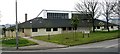
1
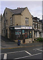
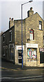
G K Cultural Flicks - Whetley Hill
Image: © Betty Longbottom
Taken: 25 Oct 2009
0.01 miles
3
New building at #41 Whetley Hill at Juniper Close junction
Ordnance Survey documents indicate that in 1957 a benchmark levelled at 143.692m above Newlyn Datum was verified on a wall fronting #41 Whetley Hill. The wall appears to have been removed with the construction of the new building on the plot between the houses and the main road
Image: © Roger Templeman
Taken: 17 Jun 2017
0.04 miles
4
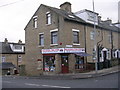
Khan General Food Store - Hollings Road
Image: © Betty Longbottom
Taken: 21 Nov 2010
0.05 miles
6

Junction of Lincoln Road and Whetley Hill (B6144), Bradford
Image: © habiloid
Taken: 23 Apr 2012
0.06 miles
7
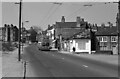
Whetley Hill, Bradford – 1972
Trolleybus 842 descends towards the city centre on the final day of regular trolleybus operation in Bradford and Britain. The buildings on Globe Fold to the right have since disappeared, but the open ground on the left hand side has been redeveloped.
This is one of a series of views featuring buses in the 60s, 70s, and 80s. http://www.geograph.org.uk/search.php?i=137652761
Image: © Alan Murray-Rust
Taken: 24 Mar 1972
0.07 miles
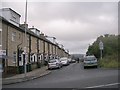
9
Hollings Road - viewed from Walker Drive
Image: © Betty Longbottom
Taken: 21 Jun 2009
0.07 miles
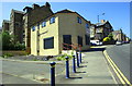
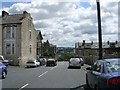
10
Whetley Hill Resource Centre
Run by Bradford Metropolitan District Council.
Image: © Betty Longbottom
Taken: 21 Apr 2007
0.08 miles