IMAGES TAKEN NEAR TO
Hollings Road, BRADFORD, BD8 8PR
Introduction
This page details the photographs taken nearby to Hollings Road, BD8 8PR by members of the Geograph project.
The Geograph project started in 2005 with the aim of publishing, organising and preserving representative images for every square kilometre of Great Britain, Ireland and the Isle of Man.

There are currently over 7.5m images from over14,400 individuals and you can help contribute to the project by visiting https://www.geograph.org.uk
Image Map
Images are licensed for reuse under creativecommons.org/licenses/by-sa/2.0
Notes
- Clicking on the map will re-center to the selected point.
- The higher the marker number, the further away the image location is from the centre of the postcode.
Image Listing (128 Images Found)
Images are licensed for reuse under creativecommons.org/licenses/by-sa/2.0
Image
Details
Distance
2
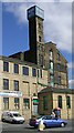
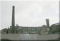
H Hey & Co Ltd - Thornton Road
Now in small business use.
Image: © Betty Longbottom
Taken: 18 Apr 2007
0.01 miles

5
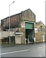
The Furniture Mill - Hollings Road, Thornton Road
The sign above the blocked up doorway reads 'The Furniture Mill'. Contained within the derelict building itself are several items of furniture.
Image: © Betty Longbottom
Taken: 2 Dec 2008
0.02 miles
9
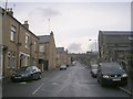
Thornton Road - viewed from Fearnsides Street
Image: © Betty Longbottom
Taken: 25 Oct 2011
0.05 miles
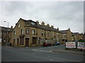
10
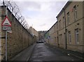
Fearnsides Street - Thornton Road
Image: © Betty Longbottom
Taken: 25 Oct 2011
0.05 miles