IMAGES TAKEN NEAR TO
Salt Street, BRADFORD, BD8 8BH
Introduction
This page details the photographs taken nearby to Salt Street, BD8 8BH by members of the Geograph project.
The Geograph project started in 2005 with the aim of publishing, organising and preserving representative images for every square kilometre of Great Britain, Ireland and the Isle of Man.

There are currently over 7.5m images from over14,400 individuals and you can help contribute to the project by visiting https://www.geograph.org.uk
Image Map
Images are licensed for reuse under creativecommons.org/licenses/by-sa/2.0
Notes
- Clicking on the map will re-center to the selected point.
- The higher the marker number, the further away the image location is from the centre of the postcode.
Image Listing (176 Images Found)
Images are licensed for reuse under creativecommons.org/licenses/by-sa/2.0
Image
Details
Distance
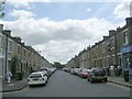
1
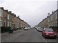
Carlisle Place - looking towards Carlisle Road
Image: © Betty Longbottom
Taken: 4 Jan 2011
0.04 miles

3
Laburnum Street - looking towards Lumb Lane
Image: © Betty Longbottom
Taken: 4 Jan 2011
0.06 miles
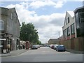
5
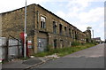
Derelict Lund Humphries works, Priestman Street
There is an Ordnance Survey benchmark Image on the near corner, road face, of the building
Image: © Roger Templeman
Taken: 13 Jul 2017
0.07 miles
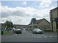
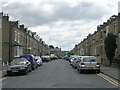
7
Lister View - viewed from Libby Street
Image: © Betty Longbottom
Taken: 4 Jan 2011
0.07 miles
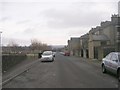
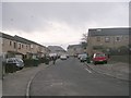
10

Carlisle Terrace - looking towards Carlisle Road
Image: © Betty Longbottom
Taken: 4 Jan 2011
0.08 miles