IMAGES TAKEN NEAR TO
Southfield Square, BRADFORD, BD8 7SN
Introduction
This page details the photographs taken nearby to Southfield Square, BD8 7SN by members of the Geograph project.
The Geograph project started in 2005 with the aim of publishing, organising and preserving representative images for every square kilometre of Great Britain, Ireland and the Isle of Man.

There are currently over 7.5m images from over14,400 individuals and you can help contribute to the project by visiting https://www.geograph.org.uk
Image Map (Loading...)


Getting Data...Please wait
Leaflet Map data © OpenStreetMap
Images are licensed for reuse under creativecommons.org/licenses/by-sa/2.0
Notes
- Clicking on the map will re-center to the selected point.
- The higher the marker number, the further away the image location is from the centre of the postcode.
Image Listing (187 Images Found)
Images are licensed for reuse under creativecommons.org/licenses/by-sa/2.0
Image
Details
Distance
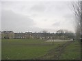
1
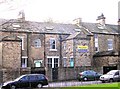
Central Jamia Mosque - Laburnum Street, Lumb Lane
Image: © Betty Longbottom
Taken: 11 Nov 2008
0.01 miles
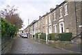
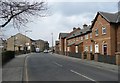
3
Mosque, Southfield Square, Manningham
This long terrace of houses is Grade II listed.
Image: © Humphrey Bolton
Taken: 8 Apr 2013
0.02 miles
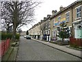
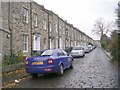
6

Carlisle Terrace - looking towards Carlisle Road
Image: © Betty Longbottom
Taken: 4 Jan 2011
0.04 miles
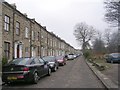
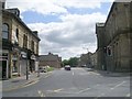
7

Southfield Square - looking towards Lumb Lane
Image: © Betty Longbottom
Taken: 4 Jan 2011
0.05 miles
8
Houses dated 1989, Lumb Lane. Manningham
Image: © Humphrey Bolton
Taken: 8 Apr 2013
0.05 miles
10
Lumb Lane - viewed from Carlisle Road
Image: © Betty Longbottom
Taken: 21 Jun 2009
0.05 miles