IMAGES TAKEN NEAR TO
Fern Terrace, BRADFORD, BD8 7QD
Introduction
This page details the photographs taken nearby to Fern Terrace, BD8 7QD by members of the Geograph project.
The Geograph project started in 2005 with the aim of publishing, organising and preserving representative images for every square kilometre of Great Britain, Ireland and the Isle of Man.

There are currently over 7.5m images from over14,400 individuals and you can help contribute to the project by visiting https://www.geograph.org.uk
Image Map
Images are licensed for reuse under creativecommons.org/licenses/by-sa/2.0
Notes
- Clicking on the map will re-center to the selected point.
- The higher the marker number, the further away the image location is from the centre of the postcode.
Image Listing (276 Images Found)
Images are licensed for reuse under creativecommons.org/licenses/by-sa/2.0
Image
Details
Distance
2
Benchmark on #10 St Mary's Road
Ordnance Survey cut mark benchmark described on the Bench Mark Database at www.bench-marks.org.uk/bm86743
Image: © Roger Templeman
Taken: 13 Jul 2017
0.03 miles
3
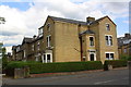
#10 St Mary's Road and houses on Welbury Drive
There is an Ordnance Survey benchmark Image on the left hand face of the nearest house under the Welbury Drive name sign
Image: © Roger Templeman
Taken: 13 Jul 2017
0.03 miles
5
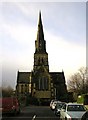
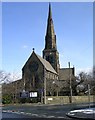
St Paul's Church, Manningham, Bradford
Viewed from St Paul's Road.
Image: © Stephen Armstrong
Taken: 25 Nov 2009
0.04 miles
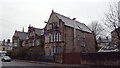
6
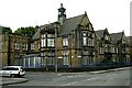
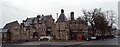
St Catherine's Home - St Mary's Road
Built 1898, this was erected by Joseph and Mary Cawthra of Horton Hall in memory of their son, John William. Before it closed it was used as a local community hospital, mainly for elderly patients.
Image: © Betty Longbottom
Taken: 4 Aug 2007
0.04 miles
7
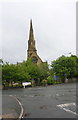
St Paul's Church
There is an Ordnance Survey benchmark Image on the front of the church on the face towards the camera
Image: © Roger Templeman
Taken: 20 Jul 2017
0.04 miles
8
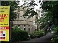
Bradford Children's Hospital - St Mary's Road
This former hospital has lately been used as a Nursing Home but is now empty and up for sale or let.
Image: © Betty Longbottom
Taken: 4 Aug 2007
0.04 miles
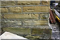
10

Benchmark on #57 St Paul's Road
Ordnance Survey cut mark benchmark described on the Bench Mark Database at www.bench-marks.org.uk/bm86846
Image: © Roger Templeman
Taken: 20 Jul 2017
0.05 miles