IMAGES TAKEN NEAR TO
Manningham Lane, BRADFORD, BD8 7NE
Introduction
This page details the photographs taken nearby to Manningham Lane, BD8 7NE by members of the Geograph project.
The Geograph project started in 2005 with the aim of publishing, organising and preserving representative images for every square kilometre of Great Britain, Ireland and the Isle of Man.

There are currently over 7.5m images from over14,400 individuals and you can help contribute to the project by visiting https://www.geograph.org.uk
Image Map
Images are licensed for reuse under creativecommons.org/licenses/by-sa/2.0
Notes
- Clicking on the map will re-center to the selected point.
- The higher the marker number, the further away the image location is from the centre of the postcode.
Image Listing (224 Images Found)
Images are licensed for reuse under creativecommons.org/licenses/by-sa/2.0
Image
Details
Distance
1
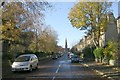
The Heathers Rest Home - Manningham Lane
Image: © Betty Longbottom
Taken: 5 Apr 2007
0.02 miles
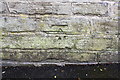
2
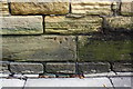
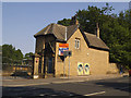
Benchmark on #306 Manningham Lane
Ordnance Survey cut mark benchmark described on the Bench Mark Database at http://www.bench-marks.org.uk/bm87439
Image: © Roger Templeman
Taken: 10 Aug 2017
0.03 miles
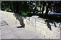
3
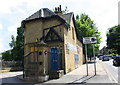
Lodge building, #306 Manningham Lane
There is an OS benchmark Image about 3 feet from the near angle of the building on its road face
Image: © Roger Templeman
Taken: 10 Aug 2017
0.03 miles
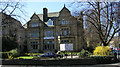
4
Lodge to Bolton Royd, Manningham Lane
For the main building see Image The lodge, along with the rest of the site, was for sale as of 2018.
Image: © Stephen Craven
Taken: 27 May 2018
0.03 miles
6
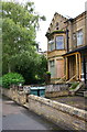
#9 St Paul's Road
There is an Ordnance Survey benchmark Image on the wall in front of the house
Image: © Roger Templeman
Taken: 20 Jul 2017
0.03 miles
7
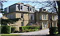
Bolton Royd - Manningham Lane
This is run by Bradford College as an Adult Eduation Centre
Image: © Betty Longbottom
Taken: 5 Apr 2007
0.04 miles
8
Old milestone set in wall on NE side of Manningham Lane (A650)
There is a weathered Ordnance Survey benchmark on the front of the stone Image
Image: © Roger Templeman
Taken: 20 Jul 2017
0.04 miles
9
Benchmark on wall in front of #9 St Paul's Road
Ordnance Survey cut mark benchmark described on the Bench Mark Database at www.bench-marks.org.uk/bm86847
Image: © Roger Templeman
Taken: 20 Jul 2017
0.04 miles