IMAGES TAKEN NEAR TO
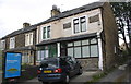
Sahara Court, BRADFORD, BD8 7DF
Introduction
This page details the photographs taken nearby to Sahara Court, BD8 7DF by members of the Geograph project.
The Geograph project started in 2005 with the aim of publishing, organising and preserving representative images for every square kilometre of Great Britain, Ireland and the Isle of Man.

There are currently over 7.5m images from over14,400 individuals and you can help contribute to the project by visiting https://www.geograph.org.uk
Image Map
Images are licensed for reuse under creativecommons.org/licenses/by-sa/2.0
Notes
- Clicking on the map will re-center to the selected point.
- The higher the marker number, the further away the image location is from the centre of the postcode.
Image Listing (171 Images Found)
Images are licensed for reuse under creativecommons.org/licenses/by-sa/2.0
Image
Details
Distance
1
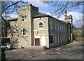
Jabez House - Queen's Road
This is described as being supported accommodation.
Image: © Betty Longbottom
Taken: 22 Mar 2008
0.03 miles
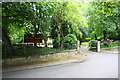
2
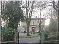
Carlton Manor Residential Home - Parkfield Road
This was originally built as Parkfield House.
Image: © Betty Longbottom
Taken: 4 Jan 2011
0.03 miles
3
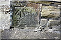
Benchmark on #34 Queen's Road
Ordnance Survey cut mark benchmark described on the Bench Mark Database at http://www.bench-marks.org.uk/bm86449
Image: © Roger Templeman
Taken: 13 Jul 2017
0.04 miles
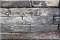
4
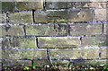
Benchmark on Parkfield Road wall outside #23
Ordnance Survey cut mark benchmark described on the Bench Mark Database at http://www.bench-marks.org.uk/bm86466
Image: © Roger Templeman
Taken: 13 Jul 2017
0.05 miles
5
Houses on Queen's Road
There is an OS benchmark Image at the base of the porch extension on the near corner of the nearest house (#34)
Image: © Roger Templeman
Taken: 13 Jul 2017
0.05 miles
6
Wall of Carlton Manor, Parkfield Road
There is an OS benchmark Image on the wall
Image: © Roger Templeman
Taken: 13 Jul 2017
0.05 miles
7
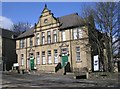
Queen's House - Queen's Road
This is a project run by Barnardo's.
Image: © Betty Longbottom
Taken: 22 Mar 2008
0.06 miles
8
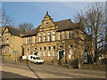
Queens House, Queens Road, Bradford
Now occupied by Barnardos. Formerly Queens Road Police Station.
Image: © Stephen Armstrong
Taken: 10 Apr 2010
0.07 miles
9

Queen's House, Queen's Road
There is an OS benchmark Image on the front of the building reached down the ramp at the right hand side of the building which was originally a Sunday school, more recently a police station, and now offices
Image: © Roger Templeman
Taken: 13 Jul 2017
0.07 miles
10
Benchmark on Queen's Road wall
Ordnance Survey cut mark benchmark described on the Bench Mark Database at http://www.bench-marks.org.uk/bm86732
Image: © Roger Templeman
Taken: 13 Jul 2017
0.07 miles