IMAGES TAKEN NEAR TO
Harrier Close, BRADFORD, BD8 0NE
Introduction
This page details the photographs taken nearby to Harrier Close, BD8 0NE by members of the Geograph project.
The Geograph project started in 2005 with the aim of publishing, organising and preserving representative images for every square kilometre of Great Britain, Ireland and the Isle of Man.

There are currently over 7.5m images from over14,400 individuals and you can help contribute to the project by visiting https://www.geograph.org.uk
Image Map (65 Images)


Getting Data...Please wait
Leaflet Map data © OpenStreetMap
Images are licensed for reuse under creativecommons.org/licenses/by-sa/2.0
Notes
- Clicking on the map will re-center to the selected point.
- The higher the marker number, the further away the image location is from the centre of the postcode.
Image Listing (65 Images Found)
Images are licensed for reuse under creativecommons.org/licenses/by-sa/2.0
Image
Details
Distance
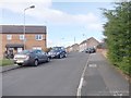
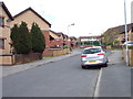
2
Goldcrest Avenue - viewed from Marmion Avenue
Image: © Betty Longbottom
Taken: 5 May 2012
0.03 miles
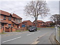
4

Willow Bank Care Village - Bell Dean Road
Image: © Betty Longbottom
Taken: 16 Feb 2008
0.05 miles
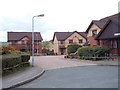
5
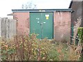
Electricity Substation No 954 - Bell Dean Road
Image: © Betty Longbottom
Taken: 27 Oct 2012
0.05 miles
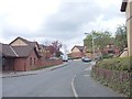
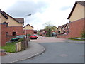
6

Bell Dean Road, Lower Grange
Looking towards Allerton from near the junction with Pity Beck View.
Image: © Richard Vince
Taken: 16 Sep 2022
0.05 miles
8
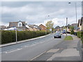
Bell Dean Road - viewed from Marmion Avenue
Image: © Betty Longbottom
Taken: 5 May 2012
0.07 miles