IMAGES TAKEN NEAR TO
Bull Royd Lane, BRADFORD, BD8 0LA
Introduction
This page details the photographs taken nearby to Bull Royd Lane, BD8 0LA by members of the Geograph project.
The Geograph project started in 2005 with the aim of publishing, organising and preserving representative images for every square kilometre of Great Britain, Ireland and the Isle of Man.

There are currently over 7.5m images from over14,400 individuals and you can help contribute to the project by visiting https://www.geograph.org.uk
Image Map
Images are licensed for reuse under creativecommons.org/licenses/by-sa/2.0
Notes
- Clicking on the map will re-center to the selected point.
- The higher the marker number, the further away the image location is from the centre of the postcode.
Image Listing (86 Images Found)
Images are licensed for reuse under creativecommons.org/licenses/by-sa/2.0
Image
Details
Distance
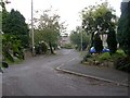
1
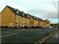
Bull Royd Lane, Bradford
A recent housing development, built in 2017/18.
Image: © Stephen Armstrong
Taken: 22 Dec 2020
0.01 miles
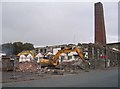
2
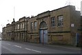
US Metallic Packing Co Ltd - Allerton Road
In process of demolition.
Image: © Betty Longbottom
Taken: 3 Oct 2007
0.02 miles
3
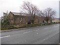
Electricity Substation No 105 - Bull Royd Lane
Image: © Betty Longbottom
Taken: 11 Jan 2012
0.04 miles
4
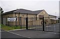
Manningham Ward Labour Club - Bull Royd Lane
Image: © Betty Longbottom
Taken: 3 Oct 2007
0.04 miles
5
US Metallic Packing Co Ltd - Allerton Road
In process of demolition.
Image: © Betty Longbottom
Taken: 3 Oct 2007
0.05 miles
7
Bull Royd Avenue - viewed from Bull Royd Crescent
Image: © Betty Longbottom
Taken: 11 Jan 2012
0.06 miles
10
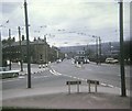
Bradford Trolleybus at Four Lane Ends
A Bradford trolleybus in Allerton Road, BD8 0BJ, near the junction of Squire Lane and West Park Road, on a last day (26th March, 1972) tour of the system. The wiring to Allerton (Route 16) which went along Allerton Road on the extreme right of the picture, had already been dismantled.
Image: © David Hillas
Taken: 26 Mar 1972
0.08 miles