IMAGES TAKEN NEAR TO
Leaventhorpe Lane, BRADFORD, BD8 0EG
Introduction
This page details the photographs taken nearby to Leaventhorpe Lane, BD8 0EG by members of the Geograph project.
The Geograph project started in 2005 with the aim of publishing, organising and preserving representative images for every square kilometre of Great Britain, Ireland and the Isle of Man.

There are currently over 7.5m images from over14,400 individuals and you can help contribute to the project by visiting https://www.geograph.org.uk
Image Map
Images are licensed for reuse under creativecommons.org/licenses/by-sa/2.0
Notes
- Clicking on the map will re-center to the selected point.
- The higher the marker number, the further away the image location is from the centre of the postcode.
Image Listing (42 Images Found)
Images are licensed for reuse under creativecommons.org/licenses/by-sa/2.0
Image
Details
Distance
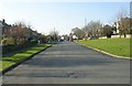
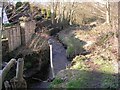
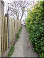
1

Leaventhorpe Lane
Approaching the bridge which crosses Pitty Beck.
Image: © Mark Anderson
Taken: 23 Jan 2022
0.01 miles
3
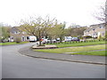
Blackburn Close - Leaventhorpe Lane
Image: © Betty Longbottom
Taken: 5 May 2012
0.04 miles
6
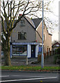
Wilsons Sandwich Bar - Thornton Road
Image: © Betty Longbottom
Taken: 11 Nov 2009
0.10 miles
7
Leaventhorpe Close - Leaventhorpe Avenue
Image: © Betty Longbottom
Taken: 5 May 2012
0.11 miles
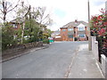
8
Middlebrook Way - viewed from Leaventhorpe Lane
Image: © Betty Longbottom
Taken: 5 May 2012
0.11 miles
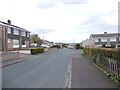
9
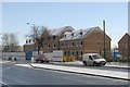
New Housing - Thornton Road opposite Rhodesway
Image: © Betty Longbottom
Taken: 2 Dec 2008
0.11 miles