IMAGES TAKEN NEAR TO
Hollingwood Lane, BRADFORD, BD7 4BH
Introduction
This page details the photographs taken nearby to Hollingwood Lane, BD7 4BH by members of the Geograph project.
The Geograph project started in 2005 with the aim of publishing, organising and preserving representative images for every square kilometre of Great Britain, Ireland and the Isle of Man.

There are currently over 7.5m images from over14,400 individuals and you can help contribute to the project by visiting https://www.geograph.org.uk
Image Map
Images are licensed for reuse under creativecommons.org/licenses/by-sa/2.0
Notes
- Clicking on the map will re-center to the selected point.
- The higher the marker number, the further away the image location is from the centre of the postcode.
Image Listing (55 Images Found)
Images are licensed for reuse under creativecommons.org/licenses/by-sa/2.0
Image
Details
Distance
1
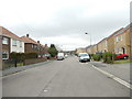
Tanner Hill Road - looking towards Hollingwood Lane
Image: © Betty Longbottom
Taken: 20 Feb 2012
0.11 miles
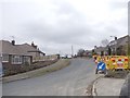
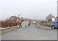
2

Pasture Rise - looking towards Pasture Lane
Image: © Betty Longbottom
Taken: 26 May 2012
0.11 miles
5
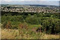
View towards Allerton
From a vantage point in the Horton Bank Country Park - this looks north over the valley created by Thornton Beck, towards the Bradford suburb of Allerton
Image: © Chris Heaton
Taken: 26 Aug 2016
0.13 miles
6
Welbeck Rise - viewed from Welbeck Drive
Image: © Betty Longbottom
Taken: 20 Feb 2012
0.14 miles

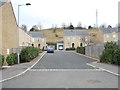
8

Maythorne Crescent - Pasture Close
Image: © Betty Longbottom
Taken: 26 May 2012
0.16 miles
9
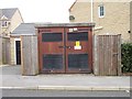
Electricity Substation No 523 - Dewberry Close
Image: © Betty Longbottom
Taken: 20 Feb 2012
0.17 miles
10
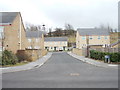
Dewberry Close - Tanner Hill Road
Image: © Betty Longbottom
Taken: 20 Feb 2012
0.17 miles