IMAGES TAKEN NEAR TO
St. Margarets Road, BRADFORD, BD7 3AB
Introduction
This page details the photographs taken nearby to St. Margarets Road, BD7 3AB by members of the Geograph project.
The Geograph project started in 2005 with the aim of publishing, organising and preserving representative images for every square kilometre of Great Britain, Ireland and the Isle of Man.

There are currently over 7.5m images from over14,400 individuals and you can help contribute to the project by visiting https://www.geograph.org.uk
Image Map
Images are licensed for reuse under creativecommons.org/licenses/by-sa/2.0
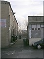
Notes
- Clicking on the map will re-center to the selected point.
- The higher the marker number, the further away the image location is from the centre of the postcode.
Image Listing (107 Images Found)
Images are licensed for reuse under creativecommons.org/licenses/by-sa/2.0
Image
Details
Distance
1
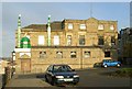
Masjid Noorul Islam - St Margaret's Road
Image: © Betty Longbottom
Taken: 3 Nov 2007
0.05 miles
2
Building at junction of All Saints Road & Great Horton Road
If anyone knows what this was originally built as, please let me know.
Image: © Betty Longbottom
Taken: 3 Nov 2007
0.06 miles
3
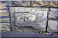
Benchmark on wall on NW side of Great Horton Road
Ordnance Survey cut mark benchmark described on the Bench Mark Database at www.bench-marks.org.uk/bm24283
Image: © Roger Templeman
Taken: 26 Jun 2017
0.06 miles
4
Anam's Indian Restaurant - Great Horton Road
Image: © Betty Longbottom
Taken: 3 Nov 2007
0.06 miles
6
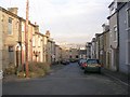
Alexandra Street - Great Horton Road
Image: © Betty Longbottom
Taken: 17 Dec 2008
0.06 miles
7
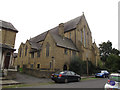
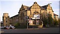
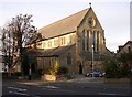
Former St Columba's church, Bradford
This is the north end of the church facing St Margaret's Place; for the other end see Image It was built in 1899-1902, by local architects Thomas Healey Jnr & Francis Healey. There was never a tower. The church was re-ordered in the mid-1980s, but closed in 2004 at which time the benefice and parish were united with St Wilfrid's. The building was leased to Horton Outreach as a restaurant but I don't know whether that is still the case; there were no signs outside in 2016.
Image: © Stephen Craven
Taken: 10 Sep 2016
0.06 miles
8
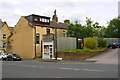
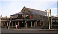
Primrose Hill houses, taxi booth and entrance to Anam's Restaurant
Ordnance Survey documents indicate that in 1956 a benchmark levelled at 149.450m above Newlyn Datum was verified on #209 Great Horton Road which was to the right of the taxi booth. The site of that building is now the entrance to Anam's carpark, with the restaurant being #211 on the site of Columbus Works.
Image: © Roger Templeman
Taken: 26 Jun 2017
0.06 miles
10
St Columba's Church - Horton Grange Road
This Church is now a restaurant known as 'The Restaurant in the Church Ltd'.
Image: © Betty Longbottom
Taken: 3 Nov 2007
0.07 miles