IMAGES TAKEN NEAR TO
Winburg Road, BRADFORD, BD7 2ET
Introduction
This page details the photographs taken nearby to Winburg Road, BD7 2ET by members of the Geograph project.
The Geograph project started in 2005 with the aim of publishing, organising and preserving representative images for every square kilometre of Great Britain, Ireland and the Isle of Man.

There are currently over 7.5m images from over14,400 individuals and you can help contribute to the project by visiting https://www.geograph.org.uk
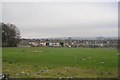
Image Map
Images are licensed for reuse under creativecommons.org/licenses/by-sa/2.0
Notes
- Clicking on the map will re-center to the selected point.
- The higher the marker number, the further away the image location is from the centre of the postcode.
Image Listing (93 Images Found)
Images are licensed for reuse under creativecommons.org/licenses/by-sa/2.0
Image
Details
Distance
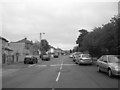
1
Brandfort Street - Warrenton Place
Image: © Betty Longbottom
Taken: 23 Dec 2008
0.05 miles
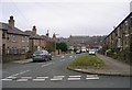
5
Spencer Road - viewed from Farnham Road
Image: © Betty Longbottom
Taken: 4 Oct 2011
0.06 miles
6
Recreation Ground - Warrenton Place
Image: © Betty Longbottom
Taken: 23 Dec 2008
0.06 miles
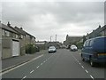
8
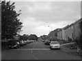
Farnham Road - viewed from Spencer Road
Image: © Betty Longbottom
Taken: 4 Oct 2011
0.07 miles
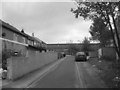
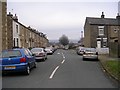
9
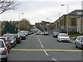
Farnham Road
About half way up the road (where the black car is emerging from the left), there was a, long since demolished, railway bridge, which carried the GNR Bradford Exchange to Queensbury Line.
Image: © Stephen Armstrong
Taken: 16 Apr 2015
0.08 miles
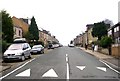
10
Hartington Terrace - Spencer Road
Image: © Betty Longbottom
Taken: 23 Dec 2008
0.08 miles