IMAGES TAKEN NEAR TO
Hilton Road, BRADFORD, BD7 2ED
Introduction
This page details the photographs taken nearby to Hilton Road, BD7 2ED by members of the Geograph project.
The Geograph project started in 2005 with the aim of publishing, organising and preserving representative images for every square kilometre of Great Britain, Ireland and the Isle of Man.

There are currently over 7.5m images from over14,400 individuals and you can help contribute to the project by visiting https://www.geograph.org.uk
Image Map
Images are licensed for reuse under creativecommons.org/licenses/by-sa/2.0
Notes
- Clicking on the map will re-center to the selected point.
- The higher the marker number, the further away the image location is from the centre of the postcode.
Image Listing (88 Images Found)
Images are licensed for reuse under creativecommons.org/licenses/by-sa/2.0
Image
Details
Distance
1
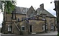
Ukrainian Community Centre - Legrams Lane
Image: © Betty Longbottom
Taken: 29 May 2007
0.01 miles
2
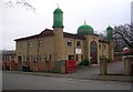
Jamia Mosque Tabligh-Ul-Islam - Hilton Rd
Image: © Betty Longbottom
Taken: 23 Dec 2008
0.03 miles
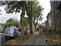
4
Ellercroft Road - looking towards Legrams Lane
Image: © Betty Longbottom
Taken: 4 Oct 2011
0.03 miles
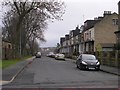
5
Ellercroft Avenue - Ellercroft Road
Image: © Betty Longbottom
Taken: 4 Oct 2011
0.04 miles
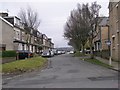
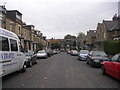
7
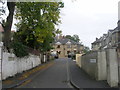
Hilton Grove - viewed from Kirkham Road
Image: © Betty Longbottom
Taken: 4 Oct 2011
0.08 miles
9
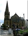
Church of Jesus Christ Apostolic Inc - Horton Grange Road
This was built in 1903 as the Tetley Street Baptist Church.
Image: © Betty Longbottom
Taken: 29 May 2007
0.08 miles
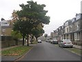
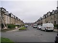
10
Ellercroft Terrace - Ellercroft Road
Image: © Betty Longbottom
Taken: 4 Oct 2011
0.09 miles