IMAGES TAKEN NEAR TO
Legrams Terrace, BRADFORD, BD7 1LN
Introduction
This page details the photographs taken nearby to Legrams Terrace, BD7 1LN by members of the Geograph project.
The Geograph project started in 2005 with the aim of publishing, organising and preserving representative images for every square kilometre of Great Britain, Ireland and the Isle of Man.

There are currently over 7.5m images from over14,400 individuals and you can help contribute to the project by visiting https://www.geograph.org.uk
Image Map
Images are licensed for reuse under creativecommons.org/licenses/by-sa/2.0
Notes
- Clicking on the map will re-center to the selected point.
- The higher the marker number, the further away the image location is from the centre of the postcode.
Image Listing (65 Images Found)
Images are licensed for reuse under creativecommons.org/licenses/by-sa/2.0
Image
Details
Distance
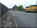
1
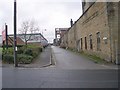
Great Russell Street - Preston Street
Image: © Betty Longbottom
Taken: 21 Nov 2010
0.01 miles
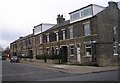
2
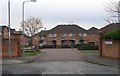
Sir Isaac Holden Place - Archibald Street
These homes were built by the North British Housing Association.
Image: © Betty Longbottom
Taken: 23 Dec 2008
0.01 miles
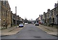
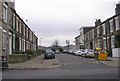
3
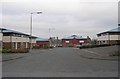
Legrams Terrace - Archibald Street
Image: © Betty Longbottom
Taken: 23 Dec 2008
0.03 miles
7
Fieldhead Street - Archibald Street
Image: © Betty Longbottom
Taken: 23 Dec 2008
0.05 miles
8
Fieldhead Street - Archibald Street
Image: © Betty Longbottom
Taken: 23 Dec 2008
0.05 miles
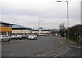
9
Great Russell Street - Archibald Street
Image: © Betty Longbottom
Taken: 23 Dec 2008
0.06 miles
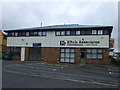
10
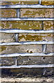
Benchmark on #64 Great Russell Street
Ordnance Survey cut mark benchmark described on the Bench Mark Database at www.bench-marks.org.uk/bm85766
Image: © Roger Templeman
Taken: 17 Jun 2017
0.06 miles