IMAGES TAKEN NEAR TO
Claremont, BRADFORD, BD7 1BG
Introduction
This page details the photographs taken nearby to Claremont, BD7 1BG by members of the Geograph project.
The Geograph project started in 2005 with the aim of publishing, organising and preserving representative images for every square kilometre of Great Britain, Ireland and the Isle of Man.

There are currently over 7.5m images from over14,400 individuals and you can help contribute to the project by visiting https://www.geograph.org.uk
Image Map
Images are licensed for reuse under creativecommons.org/licenses/by-sa/2.0
Notes
- Clicking on the map will re-center to the selected point.
- The higher the marker number, the further away the image location is from the centre of the postcode.
Image Listing (270 Images Found)
Images are licensed for reuse under creativecommons.org/licenses/by-sa/2.0
Image
Details
Distance
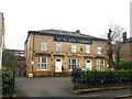
2
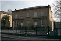
9-11 Claremont
Now occupied by the Royal British Legion.
Image: © Alan Longbottom
Taken: 14 Apr 2007
0.02 miles
5
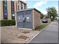
Electricity Substation No 49567 - Claremont
Image: © Betty Longbottom
Taken: 3 Jun 2015
0.03 miles
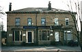
6
12-14 Claremont
Now occupied by Bradford University.
Image: © Alan Longbottom
Taken: 14 Apr 2007
0.04 miles
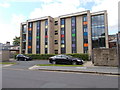
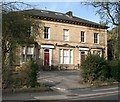
8
Astana Aliya Naqeebiya, Claremont, Bradford
Grade II Listed pair of Victorian villas, built circa 1860 https://historicengland.org.uk/listing/the-list/list-entry/1133219. Now a mosque.
Image: © Stephen Armstrong
Taken: 13 Feb 2024
0.04 miles
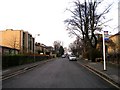
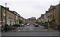
10
Mannville Terrace - Great Horton Road
Image: © Betty Longbottom
Taken: 4 Jan 2009
0.05 miles