IMAGES TAKEN NEAR TO
Lansdowne Place, BRADFORD, BD5 0BN
Introduction
This page details the photographs taken nearby to Lansdowne Place, BD5 0BN by members of the Geograph project.
The Geograph project started in 2005 with the aim of publishing, organising and preserving representative images for every square kilometre of Great Britain, Ireland and the Isle of Man.

There are currently over 7.5m images from over14,400 individuals and you can help contribute to the project by visiting https://www.geograph.org.uk
Image Map (Loading...)


Getting Data...Please wait
Leaflet Map data © OpenStreetMap
Images are licensed for reuse under creativecommons.org/licenses/by-sa/2.0
Notes
- Clicking on the map will re-center to the selected point.
- The higher the marker number, the further away the image location is from the centre of the postcode.
Image Listing (318 Images Found)
Images are licensed for reuse under creativecommons.org/licenses/by-sa/2.0
Image
Details
Distance
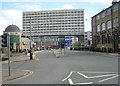
1
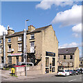
The International Restaurant, Morley Street (A647), Bradford
Image: © habiloid
Taken: 21 Sep 2023
0.01 miles
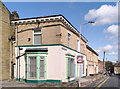
2
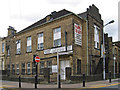
Bradford - Sawrey House
On Howard Street.
Image: © Dave Bevis
Taken: 29 Jun 2013
0.02 miles
4
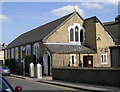
Polish Church - Edmund Street
This Catholic Church is dedicated to Our Lady of Czestochowa
Image: © Betty Longbottom
Taken: 7 Apr 2007
0.03 miles
6

Polish Community Centre & Club - Edmund Street
Image: © Betty Longbottom
Taken: 7 Apr 2007
0.03 miles
7
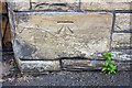
Benchmark on Morley Street wall
Ordnance Survey cut mark benchmark described on the Bench Mark Database at http://www.bench-marks.org.uk/bm28094
Image: © Roger Templeman
Taken: 26 Jun 2017
0.04 miles
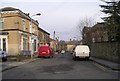
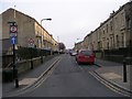
10
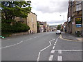
Morley Street - viewed from Claremont
Image: © Betty Longbottom
Taken: 3 Jun 2015
0.04 miles