IMAGES TAKEN NEAR TO
South View Close, BRADFORD, BD4 6PR
Introduction
This page details the photographs taken nearby to South View Close, BD4 6PR by members of the Geograph project.
The Geograph project started in 2005 with the aim of publishing, organising and preserving representative images for every square kilometre of Great Britain, Ireland and the Isle of Man.

There are currently over 7.5m images from over14,400 individuals and you can help contribute to the project by visiting https://www.geograph.org.uk
Image Map
Images are licensed for reuse under creativecommons.org/licenses/by-sa/2.0
Notes
- Clicking on the map will re-center to the selected point.
- The higher the marker number, the further away the image location is from the centre of the postcode.
Image Listing (75 Images Found)
Images are licensed for reuse under creativecommons.org/licenses/by-sa/2.0
Image
Details
Distance
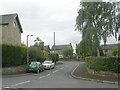
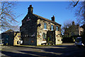
3

South View Close - looking towards South View Road
Image: © Betty Longbottom
Taken: 18 Jun 2011
0.03 miles

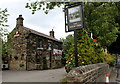
5
New Inn, East Bierley
https://www.geograph.org.uk/photo/6057468
Image: © Ian S
Taken: 23 Jan 2019
0.03 miles
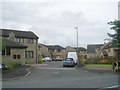
7

The New Inn and Raikes Lane, East Bierley, Hunsworth
According to the 6” map of c. 1940 the road is called Raikes Lane as far as the green, where it changes to South View Road.
Image: © Humphrey Bolton
Taken: 23 Aug 2007
0.04 miles
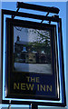
8

The New Inn, East Bierley
On south View Road.
Image: © JThomas
Taken: 27 Feb 2020
0.04 miles
9
New Inn, East Bierley
https://www.geograph.org.uk/photo/6057472
Image: © Ian S
Taken: 23 Jan 2019
0.04 miles