IMAGES TAKEN NEAR TO
BD4 0FP
Introduction
This page details the photographs taken nearby to BD4 0FP by members of the Geograph project.
The Geograph project started in 2005 with the aim of publishing, organising and preserving representative images for every square kilometre of Great Britain, Ireland and the Isle of Man.

There are currently over 7.5m images from over14,400 individuals and you can help contribute to the project by visiting https://www.geograph.org.uk
Image Map
Images are licensed for reuse under creativecommons.org/licenses/by-sa/2.0
Notes
- Clicking on the map will re-center to the selected point.
- The higher the marker number, the further away the image location is from the centre of the postcode.
Image Listing (33 Images Found)
Images are licensed for reuse under creativecommons.org/licenses/by-sa/2.0
Image
Details
Distance

5
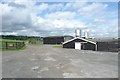
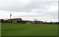
Scholebrook Farm, Tong
Livestock in sheds. The track is Scholebrook Lane, a public bridleway.
Image: © Humphrey Bolton
Taken: 18 Jun 2009
0.04 miles
6
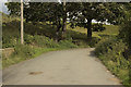
A footpath off Raikes Lane goes to Holme Wood, Bradford
Image: © Ian S
Taken: 14 Jan 2012
0.04 miles
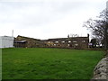
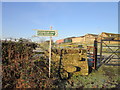
7
Scholebrook Farm
Viewed from the bridleway that runs through the farm.
Image: © Stephen Craven
Taken: 2 May 2020
0.04 miles
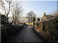
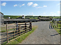
8
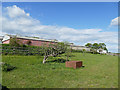
Maythorne Farm
The young trees in the foreground comprise a small orchard.
Image: © Stephen Craven
Taken: 2 May 2020
0.05 miles