IMAGES TAKEN NEAR TO
Stainforth, SETTLE, BD24 9NZ
Introduction
This page details the photographs taken nearby to BD24 9NZ by members of the Geograph project.
The Geograph project started in 2005 with the aim of publishing, organising and preserving representative images for every square kilometre of Great Britain, Ireland and the Isle of Man.

There are currently over 7.5m images from over14,400 individuals and you can help contribute to the project by visiting https://www.geograph.org.uk
Image Map (Loading...)


Getting Data...Please wait
Leaflet Map data © OpenStreetMap
Images are licensed for reuse under creativecommons.org/licenses/by-sa/2.0
Notes
- Clicking on the map will re-center to the selected point.
- The higher the marker number, the further away the image location is from the centre of the postcode.
Image Listing (67 Images Found)
Images are licensed for reuse under creativecommons.org/licenses/by-sa/2.0
Image
Details
Distance
1
A glimpse of Stainforth Youth Hostel
A glimpse of Stainforth Youth Hostel pictured on the morning after I had stayed there. The house is named Taitlands and was built in the 1840s for Thomas Joseph Redmayne. The youth hostel closed in 2007 and is now an events and wedding venue. The house is Grade II listed https://historicengland.org.uk/listing/the-list/list-entry/1166858
Image: © Philip Halling
Taken: 26 Sep 1990
0.02 miles
2
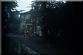
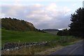
Former Youth Hostel, Stainforth
Taken in October 2006, this photo shows "Taitlands" on the B6479 road South of Stainforth. This house was erected in the 1840s and was a grade II listed building. It opened as a Youth Hostel in 1945 having 50 beds but closed in 2007. Now it is an Events and Weddings venue, its postcode being BD24 9PA.
Image: © David Hillas
Taken: 8 Oct 2006
0.03 miles

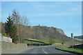
6
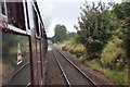
The Long Drag
The long drag is a famous incline on the Settle to Carlisle railway. It runs up to Ais Gill summit. The S&C was built by the Midland railway after a dispute with the London and North West Railway.
The route was very expensive and difficult to build, claiming several lives. British Rail tried to close the line in the 1980s but a campain prevented this. It is now an important freight, tourist and diversionary route.
Image: © Ashley Dace
Taken: 9 Oct 2010
0.13 miles
7
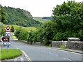
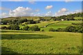
View NW from Stainforth Scar
The village of Stainforth is to the right of the B6479.
Image: © Dave Spicer
Taken: 10 Sep 2008
0.15 miles
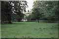
8
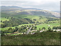
Pasture below Stainforth Scar
An animal feeder lies unused.
Image: © Christine Johnstone
Taken: 24 Jun 2023
0.15 miles