IMAGES TAKEN NEAR TO
Stainforth, SETTLE, BD24 9LJ
Introduction
This page details the photographs taken nearby to BD24 9LJ by members of the Geograph project.
The Geograph project started in 2005 with the aim of publishing, organising and preserving representative images for every square kilometre of Great Britain, Ireland and the Isle of Man.

There are currently over 7.5m images from over14,400 individuals and you can help contribute to the project by visiting https://www.geograph.org.uk
Image Map (Loading...)


Getting Data...Please wait
Leaflet Map data © OpenStreetMap
Images are licensed for reuse under creativecommons.org/licenses/by-sa/2.0
Notes
- Clicking on the map will re-center to the selected point.
- The higher the marker number, the further away the image location is from the centre of the postcode.
Image Listing (28 Images Found)
Images are licensed for reuse under creativecommons.org/licenses/by-sa/2.0
Image
Details
Distance
1
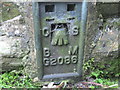
Ordnance Survey Flush Bracket G2086
This bracket can be found on a barn wall at Sherwood.
For more detail see : http://www.bench-marks.org.uk/bm11153
Image: © Peter Wood
Taken: 9 Jun 2012
0.02 miles
5
The Settle to Carlisle line crosses the River Ribble
Image: © Steve Daniels
Taken: 28 Jul 2011
0.06 miles
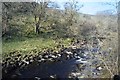
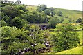
8
River Ribble
Railway crossing the River Ribble, seen from Sherwood Brow on the B6479.
Image: © Peter McDermott
Taken: 4 Oct 2020
0.07 miles