IMAGES TAKEN NEAR TO
Townhead Croft, SETTLE, BD24 9LG
Introduction
This page details the photographs taken nearby to Townhead Croft, BD24 9LG by members of the Geograph project.
The Geograph project started in 2005 with the aim of publishing, organising and preserving representative images for every square kilometre of Great Britain, Ireland and the Isle of Man.

There are currently over 7.5m images from over14,400 individuals and you can help contribute to the project by visiting https://www.geograph.org.uk
Image Map
Images are licensed for reuse under creativecommons.org/licenses/by-sa/2.0
Notes
- Clicking on the map will re-center to the selected point.
- The higher the marker number, the further away the image location is from the centre of the postcode.
Image Listing (311 Images Found)
Images are licensed for reuse under creativecommons.org/licenses/by-sa/2.0
Image
Details
Distance
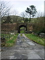
5
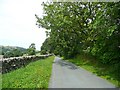
Highway, Settle
A very pleasant quiet lane, and a popular walk from the town centre. Although traffic is not actually banned, it is discouraged by 'No through road' signs.
Image: © Humphrey Bolton
Taken: 6 Aug 2009
0.04 miles
7
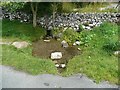
Wayside stream, Highway, Settle
A pool of crystal-clear water.
Image: © Humphrey Bolton
Taken: 6 Aug 2009
0.09 miles
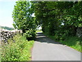
8
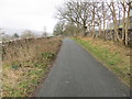
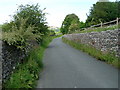
Wall and tree-lined 'Highway' between Settle and Langcliffe
Looking northward.
Image: © Peter Wood
Taken: 12 Feb 2020
0.09 miles
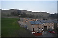
9
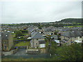
Northfields Crescent, Settle
Viewed from a passing train.
Image: © Stephen Craven
Taken: 4 Jul 2017
0.10 miles