IMAGES TAKEN NEAR TO
SETTLE, BD24 9JY
Introduction
This page details the photographs taken nearby to BD24 9JY by members of the Geograph project.
The Geograph project started in 2005 with the aim of publishing, organising and preserving representative images for every square kilometre of Great Britain, Ireland and the Isle of Man.

There are currently over 7.5m images from over14,400 individuals and you can help contribute to the project by visiting https://www.geograph.org.uk
Image Map (Loading...)


Getting Data...Please wait
Leaflet Map data © OpenStreetMap
Images are licensed for reuse under creativecommons.org/licenses/by-sa/2.0
Notes
- Clicking on the map will re-center to the selected point.
- The higher the marker number, the further away the image location is from the centre of the postcode.
Image Listing (35 Images Found)
Images are licensed for reuse under creativecommons.org/licenses/by-sa/2.0
Image
Details
Distance
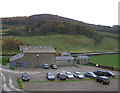
1
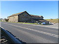
The Courtyard at Cleatop Barns
The old farm buildings at Cleatop Barns have been converted to The Courtyard, which houses The Brasserie and a small number of retail outlets, including a fine specialist cheesemonger.
Image: © John S Turner
Taken: 23 Apr 2016
0.00 miles
2
The Courtyard
Somewhere to stop for food and refreshment on the A65. It is even more useful now that the A65 bypasses Settle.
Image: © Bill Boaden
Taken: 2 Sep 2022
0.01 miles
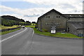
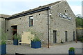
3
The Courtyard
A collection of up-market shops in former farm buildings once called Cleatop Barns beside the A65 road.
Image: © Bill Harrison
Taken: 4 Aug 2019
0.01 miles
4
The Courtyard, Cleatop Barns
The farm buildings have just been converted into a small retail park on the side of the A65 http://www.inthecourtyard.co.uk/
Image: © Alexander P Kapp
Taken: 11 Aug 2012
0.01 miles
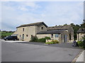
5
Cleatop Barns
Former farm buildings converted for use as a small retail park. Off the busy A65 south of Settle.
Image: © JThomas
Taken: 3 Nov 2012
0.01 miles
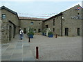
6
The Courtyard Cleatop Barns
Retail outlet next to the A65 at Cleatop Barns.
Image: © edward mcmaihin
Taken: 26 Jul 2013
0.02 miles
7
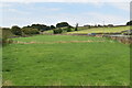
Field by the A65
At the far end of the field, the A65 goes under the Skipton to Settle railway line which is on the embankment to the left.
Image: © Bill Boaden
Taken: 2 Sep 2022
0.03 miles
8
Arable Land at Cleatop Barns
Arable land at Cleatop Barns viewed looking north east from The Courtyard.
Image: © edward mcmaihin
Taken: 26 Jul 2013
0.06 miles
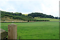
10
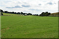
Large field near Cleatop
The A65 is seen to the left, while the Settle to Skipton railway line is on the embankment to the right.
Image: © Bill Boaden
Taken: 2 Sep 2022
0.07 miles