IMAGES TAKEN NEAR TO
Austwick Close, SETTLE, BD24 9FE
Introduction
This page details the photographs taken nearby to Austwick Close, BD24 9FE by members of the Geograph project.
The Geograph project started in 2005 with the aim of publishing, organising and preserving representative images for every square kilometre of Great Britain, Ireland and the Isle of Man.

There are currently over 7.5m images from over14,400 individuals and you can help contribute to the project by visiting https://www.geograph.org.uk
Image Map (Loading...)


Getting Data...Please wait
Leaflet Map data © OpenStreetMap
Images are licensed for reuse under creativecommons.org/licenses/by-sa/2.0
Notes
- Clicking on the map will re-center to the selected point.
- The higher the marker number, the further away the image location is from the centre of the postcode.
Image Listing (54 Images Found)
Images are licensed for reuse under creativecommons.org/licenses/by-sa/2.0
Image
Details
Distance
3
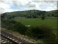
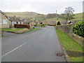
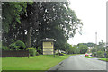
Approaching Settle
The outskirts of Settle, viewed from a passing steam-hauled train on The Dalesman excursion to the Settle-Carlisle line
Image: © Graham Hogg
Taken: 7 Aug 2017
0.11 miles
4
Brockhole Lane, Settle
Looking north along Brockhole Lane, Settle. There is an old field barn on the left of the lane, and over the wall on the right are the Dog Meadow Allotments. Some of the houses at Upper Settle can be seen in the distance on the right.
Image: © John S Turner
Taken: 1 May 2007
0.12 miles
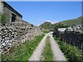
6
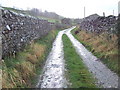
Brockhole Lane
Brockhole Lane on a cool, wet and blustery December day. A lovely example of a Yorkshire Dales walled lane that heads south from Old Settle.
Image: © Roger Nunn
Taken: 5 Dec 2007
0.13 miles
7
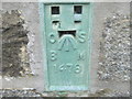
Ordnance Survey Flush Bracket 1478
This bracket can be found on the wall of a house in South Parade.
For more detail see : http://www.bench-marks.org.uk/bm1413
Image: © Peter Wood
Taken: 9 Jun 2012
0.13 miles
8
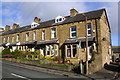
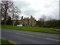
Houses of South Parade, Duke Street
There is an Ordnance Survey flush bracket Image on the side of the nearest house, near the junction of the house with its front side wall.
Image: © Roger Templeman
Taken: 14 Mar 2019
0.13 miles
9
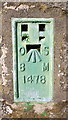
Benchmark on No.9 South Parade
Ordnance Survey flush bracket (serial number 1478) benchmark described on the Bench Mark Database at www.bench-marks.org.uk/bm1413
Image: © Roger Templeman
Taken: 14 Mar 2019
0.13 miles
10
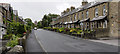
Duke Street, Settle
Terraced houses on the east side of the B6480 in Settle which at this location is known as Duke Street.
Image: © Trevor Littlewood
Taken: 15 Jun 2014
0.13 miles