IMAGES TAKEN NEAR TO
Mill Close, SETTLE, BD24 9BY
Introduction
This page details the photographs taken nearby to Mill Close, BD24 9BY by members of the Geograph project.
The Geograph project started in 2005 with the aim of publishing, organising and preserving representative images for every square kilometre of Great Britain, Ireland and the Isle of Man.

There are currently over 7.5m images from over14,400 individuals and you can help contribute to the project by visiting https://www.geograph.org.uk
Image Map
Images are licensed for reuse under creativecommons.org/licenses/by-sa/2.0
Notes
- Clicking on the map will re-center to the selected point.
- The higher the marker number, the further away the image location is from the centre of the postcode.
Image Listing (293 Images Found)
Images are licensed for reuse under creativecommons.org/licenses/by-sa/2.0
Image
Details
Distance
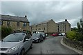
1
Footpath at Giggleswick overlooking Settle
Image: © Andy Jamieson
Taken: 15 Jun 2009
0.05 miles
2
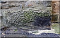
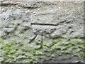
Benchmark on #15 Proctor's Row
Ordnance Survey cut mark benchmark described on the Bench Mark Database at www.bench-marks.org.uk/bm24413
Image: © Roger Templeman
Taken: 13 Apr 2019
0.05 miles
3
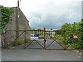
Disused highways depot
Located in King's Mill Lane. Former North Yorkshire County Council area depot, with partially demolished building.
Image: © Rose and Trev Clough
Taken: 19 May 2017
0.06 miles
4
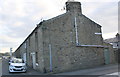
Houses on Proctor's Row
There is an Ordnance Survey benchmark Image on the rear corner of the nearest house at the junction with the porch extension
Image: © Roger Templeman
Taken: 13 Apr 2019
0.06 miles
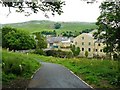
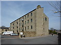
5
Towards King's Mill
Looking towards the mill buildings with construction works occurring ahead.
Image: © DS Pugh
Taken: 6 Jul 2020
0.06 miles
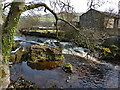
7
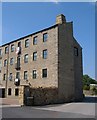
King's Mill, Settle
Another view of the converted Image from the side away from the river.
Image: © Derek Harper
Taken: 29 Jun 2006
0.07 miles
8
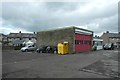
Settle fire station
The car has seen some cutting practice.
Image: © DS Pugh
Taken: 6 Jul 2020
0.07 miles
9
Ordnance Survey Cut Mark
This mark can be found on a house in Proctors Row.
For more detail see : http://www.bench-marks.org.uk/bm24413
Image: © Peter Wood
Taken: 9 Jun 2012
0.07 miles
10
River Ribble
Up stream of Giggleswick Memorial Bridge
Image: © Alexander P Kapp
Taken: 10 Apr 2010
0.07 miles