IMAGES TAKEN NEAR TO
Daleside Mews, SETTLE, BD24 0JH
Introduction
This page details the photographs taken nearby to Daleside Mews, BD24 0JH by members of the Geograph project.
The Geograph project started in 2005 with the aim of publishing, organising and preserving representative images for every square kilometre of Great Britain, Ireland and the Isle of Man.

There are currently over 7.5m images from over14,400 individuals and you can help contribute to the project by visiting https://www.geograph.org.uk
Image Map
Images are licensed for reuse under creativecommons.org/licenses/by-sa/2.0
Notes
- Clicking on the map will re-center to the selected point.
- The higher the marker number, the further away the image location is from the centre of the postcode.
Image Listing (313 Images Found)
Images are licensed for reuse under creativecommons.org/licenses/by-sa/2.0
Image
Details
Distance
1
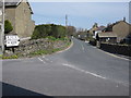
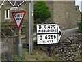
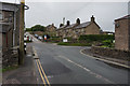
The B6479 north out of Horton in Ribblesdale
Looking north across Station Road as the B6479 heads north towards Ribblehead. Note the pre-Worboys road sign on the left.
Image: © John S Turner
Taken: 25 Apr 2009
0.02 miles
2
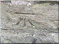
Ordnance Survey Cut Mark
This mark can be found on the wall of a house at Hillcrest.
For more detail see : http://www.bench-marks.org.uk/bm27773
Image: © Peter Wood
Taken: 9 Jun 2012
0.02 miles
3
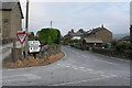
Horton-in-Ribblesdale village
Golden Lion hotel on right
Image: © John Firth
Taken: 30 Jul 2012
0.02 miles
4
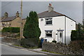
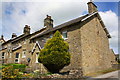
Houses on the corner
A pair of semi-detached homes on the corner
Image: © Bob Harvey
Taken: 27 Sep 2017
0.03 miles
6
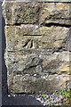
Benchmark on #1 Hillcrest
Ordnance Survey cut mark benchmark described on the Bench Mark Database at http://www.bench-marks.org.uk/bm27773
Image: © Roger Templeman
Taken: 15 Jun 2015
0.03 miles
8
Hillcrest houses
There is an OS benchmark Image on the side of the near house near the junction with the front garden wall
Image: © Roger Templeman
Taken: 15 Jun 2015
0.03 miles
9
5-13 am Station Road towards Hillcrest
Horton in Ribblesdal.
Image: © Ian S
Taken: 13 Jun 2017
0.03 miles
10
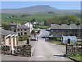
Station Road, Horton in Ribblesdale
Looking down Station Road, Horton in Ribblesdale, towards the B6479, which turns to the left in this photo. Pen-y-ghent, one of the Yorkshire Three Peaks, is prominent in the distance. See also the view looking up this hill Image The gap/stile indicated in the wall to the left of the large opening, is the other side of Image
Image: © John S Turner
Taken: 3 May 2007
0.03 miles