IMAGES TAKEN NEAR TO
Horton-in-Ribblesdale, SETTLE, BD24 0HL
Introduction
This page details the photographs taken nearby to BD24 0HL by members of the Geograph project.
The Geograph project started in 2005 with the aim of publishing, organising and preserving representative images for every square kilometre of Great Britain, Ireland and the Isle of Man.

There are currently over 7.5m images from over14,400 individuals and you can help contribute to the project by visiting https://www.geograph.org.uk
Image Map (Loading...)


Getting Data...Please wait
Leaflet Map data © OpenStreetMap
Images are licensed for reuse under creativecommons.org/licenses/by-sa/2.0
Notes
- Clicking on the map will re-center to the selected point.
- The higher the marker number, the further away the image location is from the centre of the postcode.
Image Listing (297 Images Found)
Images are licensed for reuse under creativecommons.org/licenses/by-sa/2.0
Image
Details
Distance
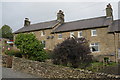
2
Hillcrest houses
There is an OS benchmark Image on the side of the near house near the junction with the front garden wall
Image: © Roger Templeman
Taken: 15 Jun 2015
0.01 miles
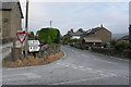
3
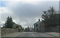
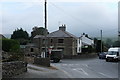
Horton-in-Ribblesdale village
Golden Lion hotel on right
Image: © John Firth
Taken: 30 Jul 2012
0.01 miles
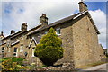
5
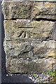
Benchmark on #1 Hillcrest
Ordnance Survey cut mark benchmark described on the Bench Mark Database at http://www.bench-marks.org.uk/bm27773
Image: © Roger Templeman
Taken: 15 Jun 2015
0.02 miles
7
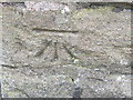
Ordnance Survey Cut Mark
This mark can be found on the wall of a house at Hillcrest.
For more detail see : http://www.bench-marks.org.uk/bm27773
Image: © Peter Wood
Taken: 9 Jun 2012
0.02 miles
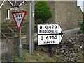
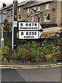
8
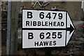
Not a Pre-worboys road sign
Sign for the B6479 and B6255 near Horton in Ribblesdale station.
Though it looks like it pre-dates the Worboys report, fellow Geographist David Howard, our resident expert, points out that the font used is too modern. He suggests comparison with a genuine original, such as Image
That leaves unanswered the question Why. What is the history behind this act of forgery?
Image: © Bob Harvey
Taken: 27 Sep 2017
0.02 miles
10
Direction Sign ? Signpost
Located on the northwest side of the junction of the B6479 Station Road and Crag Hill Road junction in Horton in Ribblesdale parish. 1 arm only. See also https://www.geograph.org.uk/photo/6022675 and https://www.geograph.org.uk/photo/2613358.
Milestone Society National ID: YW_SD8072A
Image: © P Vickery
Taken: 26 Jun 2019
0.02 miles