IMAGES TAKEN NEAR TO
Gildersleets, SETTLE, BD24 0AH
Introduction
This page details the photographs taken nearby to Gildersleets, BD24 0AH by members of the Geograph project.
The Geograph project started in 2005 with the aim of publishing, organising and preserving representative images for every square kilometre of Great Britain, Ireland and the Isle of Man.

There are currently over 7.5m images from over14,400 individuals and you can help contribute to the project by visiting https://www.geograph.org.uk
Image Map (Loading...)


Getting Data...Please wait
Leaflet Map data © OpenStreetMap
Images are licensed for reuse under creativecommons.org/licenses/by-sa/2.0
Notes
- Clicking on the map will re-center to the selected point.
- The higher the marker number, the further away the image location is from the centre of the postcode.
Image Listing (28 Images Found)
Images are licensed for reuse under creativecommons.org/licenses/by-sa/2.0
Image
Details
Distance
1
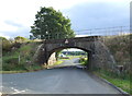
Railway bridge near Giggleswick
The line from Leeds to Morecambe.
Looking south west.
Image: © JThomas
Taken: 1 Oct 2016
0.06 miles
2
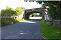
Railway Bridge SKW1/55 Gildersleet Road
Image: © Roger Templeman
Taken: 17 Aug 2015
0.06 miles
3
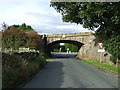
Railway bridge near Giggleswick
The line from Leeds to Morecambe.
Looking north east.
Image: © JThomas
Taken: 1 Oct 2016
0.06 miles
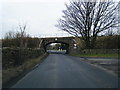
5
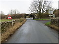
Road passing under a railway bridge to reach the A65 near Gildersleets
Looking north-eastward.
Image: © Peter Wood
Taken: 6 Feb 2019
0.07 miles
6
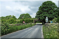
Rail bridge near Giggleswick
The road connects Rathmell and Settle. The railway connects Leeds and Morecambe.
Image: © Mary and Angus Hogg
Taken: 14 Jun 2022
0.07 miles
7
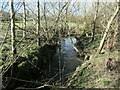
Tems Beck, looking upstream
A tributary of the River Ribble.
Image: © Christine Johnstone
Taken: 18 Feb 2024
0.07 miles
8
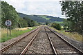
Looking down the line...
...from Giggleswick station towards Settle Junction. the differential speed-limit indicator shows 60 m.p.h. for passenger trains and 40 m.p.h. for freight trains.
Image: © Bill Harrison
Taken: 6 Aug 2019
0.07 miles
9
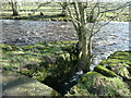
Confluence of Tems Beck and the River Ribble
The banks of the beck have been strengthened with stone blocks, some of which are held together with iron ties. There is no record of any industrial infrastructure here, so this may have been done to strengthen the foundations of the stone slab footbridge in the foreground.
Image: © Christine Johnstone
Taken: 18 Feb 2024
0.08 miles
10
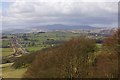
Settle Giggleswick A65 bypass
Road and rail run parallel up to Giggleswick station (near white building in kink in the bypass, Station Inn). Ingleborough is in the distance, and Giggleswick school chapel can be seen on the right before Giggleswick Quarry
Image: © William Bartlett
Taken: 14 Apr 2006
0.08 miles