IMAGES TAKEN NEAR TO
Station Road, SETTLE, BD24 0AB
Introduction
This page details the photographs taken nearby to Station Road, BD24 0AB by members of the Geograph project.
The Geograph project started in 2005 with the aim of publishing, organising and preserving representative images for every square kilometre of Great Britain, Ireland and the Isle of Man.

There are currently over 7.5m images from over14,400 individuals and you can help contribute to the project by visiting https://www.geograph.org.uk
Image Map (Loading...)


Getting Data...Please wait
Leaflet Map data © OpenStreetMap
Images are licensed for reuse under creativecommons.org/licenses/by-sa/2.0
Notes
- Clicking on the map will re-center to the selected point.
- The higher the marker number, the further away the image location is from the centre of the postcode.
Image Listing (62 Images Found)
Images are licensed for reuse under creativecommons.org/licenses/by-sa/2.0
Image
Details
Distance
1
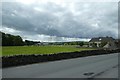
Fields beside Station Road
Looking across Station Road and onto farmland.
Image: © DS Pugh
Taken: 6 Jul 2020
0.09 miles
2

New houses off Station Road, Giggleswick
On the southern edge of the village, between the River Ribble and the Ribble Way.
Image: © Christine Johnstone
Taken: 18 Feb 2024
0.09 miles
3
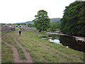
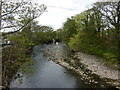
The Ribble Way near Brigholme Barn
The track leaves the Ribble temporarily as it approaches a suburb of Settle by Penny Bridge.
Image: © Karl and Ali
Taken: 31 May 2010
0.11 miles
4
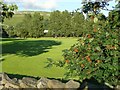
Playing field off Bankwell Road, Giggleswick
The puzzle about this view is that, apart from a glimpse of an industrial building through the trees, Settle is invisible and the distant view is just of the delightfully named Low High Hill.
Image: © Humphrey Bolton
Taken: 4 Aug 2008
0.11 miles
5
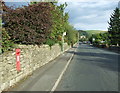
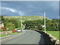
Station Road, Giggleswick
Looking east showing position of Postbox No. BD24 102.
See Image] for postbox.
Image: © JThomas
Taken: 1 Oct 2016
0.12 miles
7
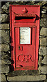
George V postbox on Station Road, Giggleswick
Postbox No. BD24 102.
See Image] for context.
Image: © JThomas
Taken: 1 Oct 2016
0.12 miles
8
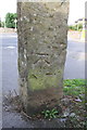
Benchmark on stone post, Raines Road
Ordnance Survey cut mark benchmark described on the Bench Mark Database at http://www.bench-marks.org.uk/bm24415
Image: © Roger Templeman
Taken: 17 Aug 2015
0.12 miles
10
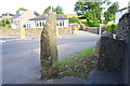
Stone seat and post at junction of Raines Road with Station Road
There is an OS benchmark Image on the stone post
Image: © Roger Templeman
Taken: 17 Aug 2015
0.13 miles