IMAGES TAKEN NEAR TO
Pommell Drive, BD2 3FQ
Introduction
This page details the photographs taken nearby to Pommell Drive, BD2 3FQ by members of the Geograph project.
The Geograph project started in 2005 with the aim of publishing, organising and preserving representative images for every square kilometre of Great Britain, Ireland and the Isle of Man.

There are currently over 7.5m images from over14,400 individuals and you can help contribute to the project by visiting https://www.geograph.org.uk
Image Map (67 Images)


Getting Data...Please wait
Leaflet Map data © OpenStreetMap
Images are licensed for reuse under creativecommons.org/licenses/by-sa/2.0
Notes
- Clicking on the map will re-center to the selected point.
- The higher the marker number, the further away the image location is from the centre of the postcode.
Image Listing (67 Images Found)
Images are licensed for reuse under creativecommons.org/licenses/by-sa/2.0
Image
Details
Distance
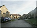
1

Ashington Close - Wharncliffe Drive
Image: © Betty Longbottom
Taken: 11 Dec 2010
0.06 miles
2

Throstle Nest Farm Riding School - Fagley Lane
Image: © Betty Longbottom
Taken: 11 Dec 2010
0.07 miles
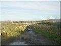
3
Fagley Lane - viewed from Green Lane
Image: © Betty Longbottom
Taken: 11 Dec 2010
0.07 miles
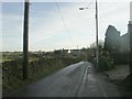
4
Green Lane - viewed from near Ashington Close
Image: © Betty Longbottom
Taken: 11 Dec 2010
0.08 miles
5
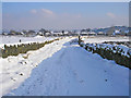
Green Lane, Fagley
Looking towards the backs of houses on Wharncliffe Drive.
Image: © John Illingworth
Taken: 3 Feb 2009
0.09 miles
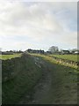
6
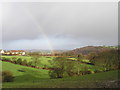
Fagley rainbow
Looking down to the fields of a riding school with Ravenscliffe Woods in the distance.
Image: © John Illingworth
Taken: 1 Jan 2007
0.10 miles
7
Martindale Close - Wharncliffe Drive
Image: © Betty Longbottom
Taken: 11 Dec 2010
0.10 miles

9

Wharncliffe Crescent - Wharncliffe Drive
Image: © Betty Longbottom
Taken: 11 Dec 2010
0.11 miles