IMAGES TAKEN NEAR TO
Beacon View, SKIPTON, BD23 6SA
Introduction
This page details the photographs taken nearby to Beacon View, BD23 6SA by members of the Geograph project.
The Geograph project started in 2005 with the aim of publishing, organising and preserving representative images for every square kilometre of Great Britain, Ireland and the Isle of Man.

There are currently over 7.5m images from over14,400 individuals and you can help contribute to the project by visiting https://www.geograph.org.uk
Image Map (Loading...)


Getting Data...Please wait
Leaflet Map data © OpenStreetMap
Images are licensed for reuse under creativecommons.org/licenses/by-sa/2.0
Notes
- Clicking on the map will re-center to the selected point.
- The higher the marker number, the further away the image location is from the centre of the postcode.
Image Listing (96 Images Found)
Images are licensed for reuse under creativecommons.org/licenses/by-sa/2.0
Image
Details
Distance
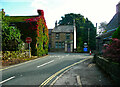
1
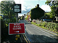
Old (pre-Worboys) road direction sign on Low Lane, Embsay
The sign in the opposite direction Image] has mileages and even includes Pateley Bridge, whereas this sign is much simpler. The road closed sign fails to indicate that the closure is on the far side of Eastby village.
Image: © Humphrey Bolton
Taken: 29 Sep 2021
0.06 miles
2
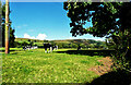
View towards Eastby Crag from Low Lane, Embsay
Image: © Humphrey Bolton
Taken: 29 Sep 2021
0.07 miles
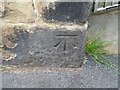
3
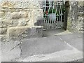
Embsay, Main Street benchmark
47 Main Street, also Salt Pie Cottage - benchmark on block above pavement. Good condition
Image: © Mel Towler
Taken: 20 Apr 2021
0.07 miles
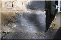
4

Embsay, 47 Main Street
Good condition benchmark on lowest block to left of garden gate. Cottage also named Salt Pie Cottage.
Image: © Mel Towler
Taken: 20 Apr 2021
0.07 miles
5
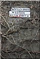
Old Direction Sign - Signpost by Main Street, Embsay with Eastby parish
No finial - 3 arms; by the UC road, in parish of Embsay with Eastby (Craven District), Embsay, junction of Main Street with Kirk Lane, fixed to side of a house at first floor level.
To be surveyed
Milestone Society National ID: YW_SE0153
Image: © Roger Templeman
Taken: Unknown
0.07 miles
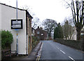
6
Kirk Lane approaching the T-junction at Cross End, Embsay
Main Street and Low Lane have pre-Worboys advance direction signs, Image] and Image], but Kirk Lane just has a modern sign directing to Skipton and signs to deter drivers of heavy goods vehicles from trying to take a short cut on narrow lanes.
Image: © Humphrey Bolton
Taken: 29 Sep 2021
0.08 miles
7
Ordnance Survey Cut Mark
This OS cut mark can be found on No47 Main Street. It marks a point 169.368m above mean sea level.
Image: © Adrian Dust
Taken: 19 Jun 2021
0.08 miles
8
Benchmark on #47 Main Street
Ordnance Survey cut mark benchmark levelled at 169.368m above Newlyn Datum
Image: © Roger Templeman
Taken: 23 Oct 2018
0.08 miles
10
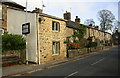
Houses on Main Street
There is an OS benchmark Image on the front of the nearest house at its far corner
Image: © Roger Templeman
Taken: 23 Oct 2018
0.09 miles