IMAGES TAKEN NEAR TO
Laurel Croft, SKIPTON, BD23 6RF
Introduction
This page details the photographs taken nearby to Laurel Croft, BD23 6RF by members of the Geograph project.
The Geograph project started in 2005 with the aim of publishing, organising and preserving representative images for every square kilometre of Great Britain, Ireland and the Isle of Man.

There are currently over 7.5m images from over14,400 individuals and you can help contribute to the project by visiting https://www.geograph.org.uk
Image Map (Loading...)


Getting Data...Please wait
Leaflet Map data © OpenStreetMap
Images are licensed for reuse under creativecommons.org/licenses/by-sa/2.0
Notes
- Clicking on the map will re-center to the selected point.
- The higher the marker number, the further away the image location is from the centre of the postcode.
Image Listing (110 Images Found)
Images are licensed for reuse under creativecommons.org/licenses/by-sa/2.0
Image
Details
Distance
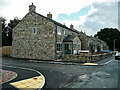
2
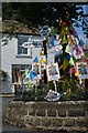
Embsay with Eastby Village Institute
Recorded on larger scale OS maps as a hall, the building is at the junction of Main Street and Laurel Croft.
Image: © Trevor Littlewood
Taken: 9 Jul 2023
0.04 miles
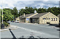
3
Embsay with Eastby Village Institute
Image: © Humphrey Bolton
Taken: 29 Sep 2021
0.04 miles
6
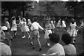
Laurel Bank, Embsay
Summer 1962.
Annual Village Garden Party held at Laurel Bank, then a large house/mansion, now built on.
The first break through the quarry to the other side had just been made.
It was probably a Saturday, judging by the cricket.
My sister Val, then 11 is the girl in the centre with white pleated skirt.
Image: © Robin Marshall
Taken: 21 Jul 1962
0.06 miles
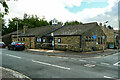
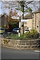
7

Old Direction Sign - Signpost by Main Street, Embsay
Annulus and bar finial - 2 arms; WR Yorks. halo with NGR by the UC road, in parish of Embsay With Eastby (Craven District), Embsay, junction of Main Street with East Lane, in round railed island outside the Elm Tree Inn.
To be surveyed
Milestone Society National ID: YW_SE0053
Image: © Milestone Society
Taken: Unknown
0.06 miles
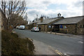
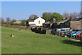
8

Embsay: Shires Lane
Looking east from its junction with East Lane . Shires Lane, and then Low Lane, will take you to the small village of Halton East, about three miles away, and subsequently to Bolton Abbey.
Image: © Dr Neil Clifton
Taken: 2 Sep 2014
0.06 miles
9
Signpost on roundabout at road junction at Elm Tree Square
Image: © Roger Templeman
Taken: 23 Oct 2018
0.06 miles
10
Behind the Village Car Park, Embsay
In a small pasture backing onto the village car park
Image: © Chris Heaton
Taken: 16 Apr 2020
0.06 miles