IMAGES TAKEN NEAR TO
Rylstone, SKIPTON, BD23 6LW
Introduction
This page details the photographs taken nearby to BD23 6LW by members of the Geograph project.
The Geograph project started in 2005 with the aim of publishing, organising and preserving representative images for every square kilometre of Great Britain, Ireland and the Isle of Man.

There are currently over 7.5m images from over14,400 individuals and you can help contribute to the project by visiting https://www.geograph.org.uk
Image Map
Images are licensed for reuse under creativecommons.org/licenses/by-sa/2.0
Notes
- Clicking on the map will re-center to the selected point.
- The higher the marker number, the further away the image location is from the centre of the postcode.
Image Listing (55 Images Found)
Images are licensed for reuse under creativecommons.org/licenses/by-sa/2.0
Image
Details
Distance
1
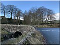
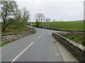
Skirse Gill Bridge
At the junction of Raikes Lane with Fleets Lane on the northern edge of Hetton village.
Image: © David Rogers
Taken: 21 Nov 2008
0.13 miles
2
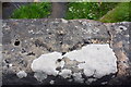
Benchmark on SE parapet of Skirse Gill Bridge
Ordnance Survey pivot benchmark levelled at 174.315m above Newlyn Datum
Image: © Roger Templeman
Taken: 10 Jun 2019
0.13 miles
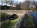
3
SE parapet of bridge over Skirse Gill Beck, Fleets Lane
There is an OS benchmark Image on top of the parapet
Image: © Roger Templeman
Taken: 10 Jun 2019
0.13 miles
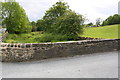
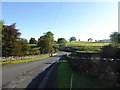
4
Skirsegill Bridge and junction of roads, Hetton
Looking north-eastward.
Image: © Peter Wood
Taken: 27 Apr 2022
0.14 miles
5

Skirse Gill Bridge
Fleets Lane crossing Skirse Gill.
Image: © Peter McDermott
Taken: 24 Apr 2021
0.14 miles
7

Direction Sign - Signpost on Fleets Lane near Hetton
Located on the northwest side of Fleets Lane opposite Raikes Lane northeast of Hetton, but in Rylstone parish. 4 arms and annulus & bar finial. For an older photo see https://www.geograph.org.uk/photo/6102898.
Milestone Society National ID: YW_SD9659
Image: © D Phillips
Taken: 19 Aug 2019
0.14 miles
8
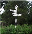
Direction Sign - Signpost, Fleets Lane, north east of Hetton
Located on the northwest side of Fleets Lane opposite Raikes Lane northeast of Hetton, but in Rylstone parish. 4 arms and annulus & bar finial. See also https://www.geograph.org.uk/photo/7861596 , https://www.geograph.org.uk/photo/6655924 and https://www.geograph.org.uk/photo/6545466.
Surveyed
Milestone Society National ID: YW_SD9659
Image: © Philip Platt
Taken: 1 Jan 2012
0.14 miles
9
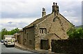
Rock Farm, Fleets Lane
There is an Ordnance Survey benchmark Image on the near corner of the building on its road face
Image: © Luke Shaw
Taken: 10 Jun 2019
0.14 miles