IMAGES TAKEN NEAR TO
Halton East, SKIPTON, BD23 6EW
Introduction
This page details the photographs taken nearby to BD23 6EW by members of the Geograph project.
The Geograph project started in 2005 with the aim of publishing, organising and preserving representative images for every square kilometre of Great Britain, Ireland and the Isle of Man.

There are currently over 7.5m images from over14,400 individuals and you can help contribute to the project by visiting https://www.geograph.org.uk
Image Map (Loading...)


Getting Data...Please wait
Leaflet Map data © OpenStreetMap
Images are licensed for reuse under creativecommons.org/licenses/by-sa/2.0
Notes
- Clicking on the map will re-center to the selected point.
- The higher the marker number, the further away the image location is from the centre of the postcode.
Image Listing (19 Images Found)
Images are licensed for reuse under creativecommons.org/licenses/by-sa/2.0
Image
Details
Distance
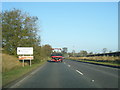
3
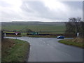
Road junction, New Laithe
Low Lane joining the A59.
Image: © JThomas
Taken: 10 Dec 2016
0.04 miles
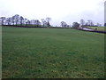
4
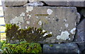
Benchmark on wall near gateway on south side of A59
Ordnance Survey cut mark benchmark levelled at 172.72m above Newlyn Datum
Image: © Roger Templeman
Taken: 1 Nov 2018
0.04 miles
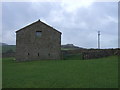
5
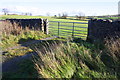
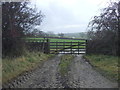
Field gateway off south side of A59
There is an OS benchmark Image on a stone in the wall to the right of the gateway
Image: © Roger Templeman
Taken: 1 Nov 2018
0.05 miles
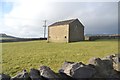
7
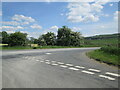
Junction on Low Lane toward A59 at New Laithe
Skipton 4 miles
Image: © Martin Dawes
Taken: 5 Jun 2021
0.10 miles
10
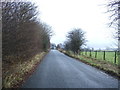
National Cycle Route 696
Looking east on Low Lane.
Image: © JThomas
Taken: 10 Dec 2016
0.14 miles