IMAGES TAKEN NEAR TO
Greenhaw, SKIPTON, BD23 6BG
Introduction
This page details the photographs taken nearby to Greenhaw, BD23 6BG by members of the Geograph project.
The Geograph project started in 2005 with the aim of publishing, organising and preserving representative images for every square kilometre of Great Britain, Ireland and the Isle of Man.

There are currently over 7.5m images from over14,400 individuals and you can help contribute to the project by visiting https://www.geograph.org.uk
Image Map
Images are licensed for reuse under creativecommons.org/licenses/by-sa/2.0
Notes
- Clicking on the map will re-center to the selected point.
- The higher the marker number, the further away the image location is from the centre of the postcode.
Image Listing (289 Images Found)
Images are licensed for reuse under creativecommons.org/licenses/by-sa/2.0
Image
Details
Distance
1
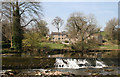
Houses across the River Wharfe
These buildings are on the south side of the river, but photographed from the north side.
Image: © Dr Neil Clifton
Taken: 9 Apr 2017
0.01 miles
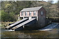
2

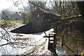
Linton Falls Hydroelectric Power Station
This is Linton Falls Hydroelectric Power Station, Grassington, North Yorkshire. It was first built in 1909, decommissioned in 1948 and restored in 2011. Although closed to the public, being a working plant, it does host occasional open days. Information available online.
Image: © Carroll Pierce
Taken: 22 Jun 2014
0.03 miles
3
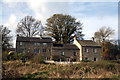
Linton: Cottages by the River Wharfe
From the left: The Old Croft; Greenhaw Cottage; Riverside Cottage.
Image: © Dr Neil Clifton
Taken: 2 Nov 2014
0.03 miles
4
Linton: Hydroelectric plant
Environmentally friendly electricity for local homes.
Image: © Dr Neil Clifton
Taken: 9 Apr 2017
0.03 miles
5
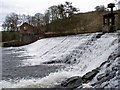
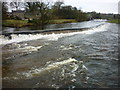
River Wharfe Grassington
Weir near Linton Falls
Image: © Kevin Rushton
Taken: 12 Apr 2004
0.03 miles

7
Linton Falls in spate
Taken from the Tin Bridge, Linton Falls, North Yorkshire, I am looking up the River Wharfe, the level of which has been raised somewhat by the first batch of winter storms. The hydroelectric power station is to be seen upriver on the left (or south) bank.
Image: © Carroll Pierce
Taken: 13 Dec 2015
0.03 miles
9
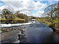
River Wharfe at Linton Falls
Looking upstream from the footbridge.
Image: © sylvia duckworth
Taken: 28 Apr 2014
0.04 miles
10
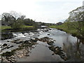
Linton: Lower and Upper Weirs from the Tin Bridge
In the distance the rebuilt turbine house at the Upper Weir can`be seen
Image: © Dr Neil Clifton
Taken: 30 Apr 2013
0.04 miles