IMAGES TAKEN NEAR TO
Drebley, SKIPTON, BD23 6AU
Introduction
This page details the photographs taken nearby to BD23 6AU by members of the Geograph project.
The Geograph project started in 2005 with the aim of publishing, organising and preserving representative images for every square kilometre of Great Britain, Ireland and the Isle of Man.

There are currently over 7.5m images from over14,400 individuals and you can help contribute to the project by visiting https://www.geograph.org.uk
Image Map
Images are licensed for reuse under creativecommons.org/licenses/by-sa/2.0
Notes
- Clicking on the map will re-center to the selected point.
- The higher the marker number, the further away the image location is from the centre of the postcode.
Image Listing (6 Images Found)
Images are licensed for reuse under creativecommons.org/licenses/by-sa/2.0
Image
Details
Distance
4
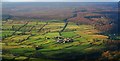
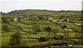
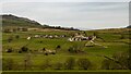
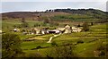
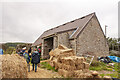
Drebley
Hamlet in Wharfedale viewed from near Simons' Seat.
Image: © Steve Partridge
Taken: 6 Jan 2008
0.03 miles
6
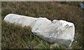
Old Boundary Marker
Fallen Knaresborough Forest Enclosure Boundary Marker at Harden Head, 1800 metres southeast of Simon's Seat. Barden parish. Inscribed 16 / K · F / 1767. Erected to delineate the Forest of Knaresborough preparatory to enclosure.
Milestone Society National ID: YW_KF16pb
Image: © D Garside
Taken: 24 May 2017
0.21 miles