IMAGES TAKEN NEAR TO
Barden, SKIPTON, BD23 6AT
Introduction
This page details the photographs taken nearby to BD23 6AT by members of the Geograph project.
The Geograph project started in 2005 with the aim of publishing, organising and preserving representative images for every square kilometre of Great Britain, Ireland and the Isle of Man.

There are currently over 7.5m images from over14,400 individuals and you can help contribute to the project by visiting https://www.geograph.org.uk
Image Map
Images are licensed for reuse under creativecommons.org/licenses/by-sa/2.0
Notes
- Clicking on the map will re-center to the selected point.
- The higher the marker number, the further away the image location is from the centre of the postcode.
Image Listing (119 Images Found)
Images are licensed for reuse under creativecommons.org/licenses/by-sa/2.0
Image
Details
Distance
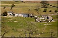
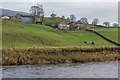
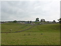
2
Holme House Farm
Seen from across the river. The main farmhouse is grade 2 listed (list entry number 11311758).
Image: © Stephen Craven
Taken: 24 Jun 2013
0.04 miles
3
Holme House Farm
Another view of Image] https://www.historicengland.org.uk/listing/the-list/list-entry/1131758 from across the River Wharfe.
Image: © Derek Harper
Taken: 28 Dec 2016
0.04 miles
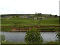
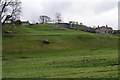
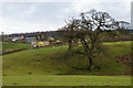
5
Towards Holme House
Looking across the River Wharfe to up towards Holme House (below the tree on the left) and Bay Cottage. Holme House itself dates from the early 19th Century and is grade II listed - see www.historicengland.org.uk/listing/the-list/list-entry/1131758.
Image: © Ian Capper
Taken: 5 Jan 2018
0.05 miles
6
Holme House Farm
Looking up from the flat land adjoining the River Wharfe. Despite what the map says, the path runs quite close to the river on this stretch.
Image: © Bill Boaden
Taken: 14 Apr 2012
0.05 miles
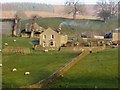
7
Holme House, near Barden Bridge
Seen from the path on the east bank of the River Wharfe. If you look carefully, you can see some newly shorn sheep in the yard. Judging by the noise, there were more sheep being shorn in a barn behind the trees. Half an hour later as I walked back along the other bank, they were being taken back to the fields.
Image: © Rich Tea
Taken: 17 Jul 2006
0.05 miles
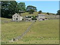
8
Holme House Farm
The farmhouse is listed https://www.historicengland.org.uk/listing/the-list/list-entry/1131758 . This view along a wall is from the Dales Way, rerouted from its mapped course to the riverside.
Image: © Derek Harper
Taken: 28 Dec 2016
0.05 miles
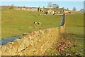
9
Dales Way trek from Bolton Abbey to Pinder Stile (37)
Farm seen on the path from Nidd Aqueduct to Burnsall
Image: © Basher Eyre
Taken: 13 Sep 2014
0.09 miles
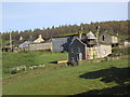
10
Towards Holme House
Looking up towards Bay Cottage, with Holme House behind it. Holme House itself dates from the early 19th Century and is grade II listed - see www.historicengland.org.uk/listing/the-list/list-entry/1131758.
Image: © Ian Capper
Taken: 5 Jan 2018
0.09 miles