IMAGES TAKEN NEAR TO
Threshfield, SKIPTON, BD23 5NR
Introduction
This page details the photographs taken nearby to BD23 5NR by members of the Geograph project.
The Geograph project started in 2005 with the aim of publishing, organising and preserving representative images for every square kilometre of Great Britain, Ireland and the Isle of Man.

There are currently over 7.5m images from over14,400 individuals and you can help contribute to the project by visiting https://www.geograph.org.uk
Image Map
Images are licensed for reuse under creativecommons.org/licenses/by-sa/2.0
Notes
- Clicking on the map will re-center to the selected point.
- The higher the marker number, the further away the image location is from the centre of the postcode.
Image Listing (8 Images Found)
Images are licensed for reuse under creativecommons.org/licenses/by-sa/2.0
Image
Details
Distance
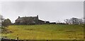
2
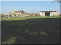
Farm on Tarns Lane
The farm buildings shown but not named on the map just to the east of Tarns Lane (B6265) seen from the bridleway.
Image: © Stephen Craven
Taken: 23 Oct 2007
0.02 miles
5
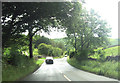
Bridleway from Linton
The bridleway from Linton as it descends towards the B6265 (Skipton-Kettlewell road).
Image: © Stephen Craven
Taken: 23 Oct 2007
0.13 miles