IMAGES TAKEN NEAR TO
Brook Street, SKIPTON, BD23 5DQ
Introduction
This page details the photographs taken nearby to Brook Street, BD23 5DQ by members of the Geograph project.
The Geograph project started in 2005 with the aim of publishing, organising and preserving representative images for every square kilometre of Great Britain, Ireland and the Isle of Man.

There are currently over 7.5m images from over14,400 individuals and you can help contribute to the project by visiting https://www.geograph.org.uk
Image Map (Loading...)


Getting Data...Please wait
Leaflet Map data © OpenStreetMap
Images are licensed for reuse under creativecommons.org/licenses/by-sa/2.0
Notes
- Clicking on the map will re-center to the selected point.
- The higher the marker number, the further away the image location is from the centre of the postcode.
Image Listing (144 Images Found)
Images are licensed for reuse under creativecommons.org/licenses/by-sa/2.0
Image
Details
Distance
1
The northern end of Hebden
This is on the northern side of the B6265, with Hebden Beck running down the middle.
Image: © Bill Boaden
Taken: 30 Mar 2013
0.02 miles
3
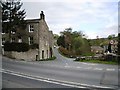
Road junction in Hebden
This photograph shows a view of a road junction formed by the intersection of the minor road from Hole Bottom (ahead) with the B6265 road (seen in the foreground). The picture was taken looking in a north-north-westerly direction towards Hebden Beck.
Image: © Philip Barker
Taken: 2 May 2010
0.02 miles
4
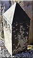
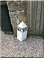
Old Bridge Marker by Brook Street, Hebden
Bridge Marker by the UC road, in parish of Hebden (Craven District), Brook Street, Hebden. Inscribed WR to mark the extent of roadway adjoining the bridge that the County was obliged to maintain. This has since been repainted, see https://www.geograph.org.uk/photo/7274986.
Surveyed
Milestone Society National ID: YW_HEBD01br
Image: © M Bardell
Taken: 19 Jul 2017
0.03 miles
5
Old Bridge Marker on Brook Street, Hebden
Bridge Marker on Brook Street at the northeast end of the old bridge over Hebden Beck. Hebden parish. Inscribed WR to mark the extent of roadway adjoining the bridge that the County was obliged to maintain. Repainted since 2017, see https://www.geograph.org.uk/photo/6048180.
Milestone Society National ID: YW_HEBD01br
Image: © P Robertson
Taken: Unknown
0.03 miles
6
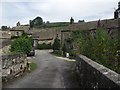
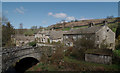
Stone cottages in Hebden
The access is via this bridge over Hebden Beck.
Image: © philandju
Taken: 8 Aug 2013
0.03 miles
9
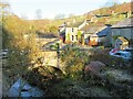
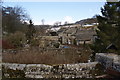
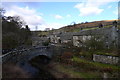
The Old bridge at Hebden
This 18th century bridge is known as 'Old Bridge' and presumably at one time carried the road between Grassington and Pateley Bridge. It is Grade II listed. The cottages on the far side are situated in Brook Street, an odd name as there are very few 'brooks' in the Dales, the majority of streams being becks.
Image: © Gordon Hatton
Taken: 29 Nov 2022
0.03 miles
10
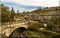
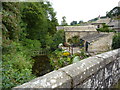
The pack horse bridge and Brook Street, Hebden
The bridge crosses Hebden Brook.
Image: © habiloid
Taken: 18 Apr 2015
0.04 miles