IMAGES TAKEN NEAR TO
Wigglesworth, SKIPTON, BD23 4RH
Introduction
This page details the photographs taken nearby to BD23 4RH by members of the Geograph project.
The Geograph project started in 2005 with the aim of publishing, organising and preserving representative images for every square kilometre of Great Britain, Ireland and the Isle of Man.

There are currently over 7.5m images from over14,400 individuals and you can help contribute to the project by visiting https://www.geograph.org.uk
Image Map
Images are licensed for reuse under creativecommons.org/licenses/by-sa/2.0
Notes
- Clicking on the map will re-center to the selected point.
- The higher the marker number, the further away the image location is from the centre of the postcode.
Image Listing (7 Images Found)
Images are licensed for reuse under creativecommons.org/licenses/by-sa/2.0
Image
Details
Distance
1
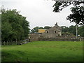
Deep Dale Head
Large farming complex in Ribblesdale
Image: © Chris Heaton
Taken: 25 Jul 2012
0.02 miles
2
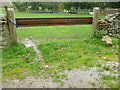
Gate replaced by metal bar
Bar obstructs public footpath
Image: © Diana M
Taken: 21 Oct 2013
0.08 miles
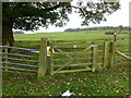
3
Gate which doesn't open fully
Gate on public footpath near Deep Dale Head.
Image: © Diana M
Taken: 21 Oct 2013
0.10 miles
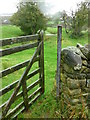
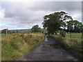
4
The Pennine Bridleway near Deep Dale Wood
Image: © Dave Kelly
Taken: 14 Jul 2020
0.16 miles
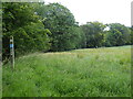
6

Ribble Way at Deep Dale
The path has been following the road, but now crosses this stile to enter a (very muddy) field.
Image: © Mr T
Taken: 7 Mar 2007
0.20 miles