IMAGES TAKEN NEAR TO
Greengate Lane, SKIPTON, BD23 4HW
Introduction
This page details the photographs taken nearby to Greengate Lane, BD23 4HW by members of the Geograph project.
The Geograph project started in 2005 with the aim of publishing, organising and preserving representative images for every square kilometre of Great Britain, Ireland and the Isle of Man.

There are currently over 7.5m images from over14,400 individuals and you can help contribute to the project by visiting https://www.geograph.org.uk
Image Map
Images are licensed for reuse under creativecommons.org/licenses/by-sa/2.0
Notes
- Clicking on the map will re-center to the selected point.
- The higher the marker number, the further away the image location is from the centre of the postcode.
Image Listing (109 Images Found)
Images are licensed for reuse under creativecommons.org/licenses/by-sa/2.0
Image
Details
Distance
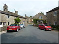
1
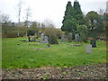
Graveyard near to the Maypole Inn on the A65
Image: © Alexander P Kapp
Taken: 19 Nov 2009
0.03 miles
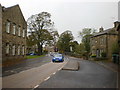
2
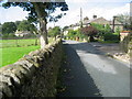
School Lane, Long Preston
Narrow lane in the village of Long Preston.
Image: © Chris Heaton
Taken: 10 Sep 2008
0.03 miles

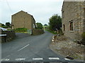
6
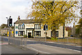
The Maypole Inn and A65, Long Preston
Image: © Tom Richardson
Taken: 1 Nov 2010
0.05 miles
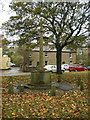
10
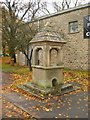
Drinking fountain
Presented by Thomas Holgate in memory of his father in 1869
Image: © Alexander P Kapp
Taken: 25 Oct 2009
0.06 miles